
If you’re in construction, architecture, or engineering — or just managing a site with unknowns — chances are you’ve heard of 3D laser scanning. But what is it exactly? And more importantly, do you need one?
Let’s break it down.
3D Laser Scanning = A Digital Twin of Your Site
A 3D laser scanning survey uses a special scanner to fire millions of laser points per second at the surfaces around it.
Each pulse bounces back, giving the scanner precise XYZ coordinates of whatever it hits — walls, columns, furniture, you name it.
The result?
A super-detailed 3D point cloud of the entire site. Think of it like a digital replica — a “reality capture” — accurate down to millimetres.
No tape measures. No guesswork. Just raw, rich, measurable data.
How It Works (In Plain English)
Here’s what actually happens on site:
- The scanner is mounted on a tripod.
- It rotates 360°, firing laser beams across a vertical and horizontal plane.
- Each beam reflects off a surface and returns to the scanner.
- The device calculates the exact distance based on the time it took to bounce back.
- Multiply that process by millions of points per second — and you’ve got a full 3D map of your environment.
It’s LiDAR technology. The same stuff used in self-driving cars — but dialled in for architectural and structural use.
The Output: More Than Just Dots
That cloud of points can be processed into:
- 2D floor plans
- Elevations and cross-sections
- Fully navigable 3D models
- BIM-ready geometry
In other words, you can go from “what the heck does this site look like?” to “here’s a CAD drawing accurate within ±2mm.”

Why It Beats Traditional Surveys
Let’s say you’re working with an old building. No drawings exist. Floors are warped. Beams aren’t straight.
You could spend days measuring manually… or scan the entire building in hours — capturing every twist and quirk instantly.
Pro tip: Scanning is also non-contact. No ladders. No touching fragile surfaces. Perfect for heritage sites or risky structures.
How Does 3D Laser Scanning Actually Work?
You’ve seen the buzzwords: “high-speed data capture,” “point clouds,” “digital twin.” But what happens on the ground when we show up with a 3D laser scanner?
Let’s peel back the curtain.
The Scanner: Like a Camera on Steroids
Picture this: a sleek device on a tripod, slowly spinning like something out of sci-fi.
But instead of taking photos, it fires out tens of thousands of laser pulses per second in all directions — 360° horizontally, almost 300° vertically.
Each laser pulse hits a surface (a wall, column, ceiling) and reflects back.
The scanner measures how long that round trip took — and since we know the speed of light, it calculates exactly how far that surface is.
Do that a few million times?
Boom — you’ve got a detailed 3D map of everything around.
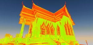
The “Point Cloud” Explained
Every dot in that map is a data point with XYZ coordinates.
The collective result is called a point cloud — basically a 3D swarm of millions (or billions) of dots that form the shape of the space.
Zoom in and you’ll see the outline of walls, doors, windows, even the slope in an old floorboard. It’s freaky accurate.
And if the scanner has a built-in camera? You’ll get photo-realistic colour overlays too.
Multiple Scans = Full Coverage
Since the scanner can’t see through walls (line-of-sight only), we move it around the space:
- One scan in the centre of each room
- One in hallways and doorways
- A few outside for façades or landscaping
Each scan creates its own point cloud. We stitch them together using registration software that aligns the overlap — or uses reflective targets placed on site.
That gives us one unified 3D model with zero gaps.
Accuracy You Can Bet the Build On
Professional scanners like the Leica RTC360 can hit millimetre precision under ideal conditions.
That’s tight enough to detect bowed walls, sagging rooflines, or even that sneaky tilt in a chimney stack.
Compared to old-school hand measurements? It’s not even close.
Fast and Risk-Free
Let’s talk speed.
You can scan a room in minutes. A whole building in a few hours. No ladders. No scaffolding. No disrupting occupants.
Even hazardous or high-up areas can be scanned from ground level — huge win for health & safety.
And here’s the best part: once the site is scanned, you’ve got everything. No “oops, we missed that corner.” Need another measurement later? Just pull it from the point cloud.
Why 3D Laser Scanning Is a No-Brainer for Many Projects
So now you know how it works. But why would you choose laser scanning over traditional surveying?
Here’s what sets it apart — and why more architects, engineers, and developers are demanding it.
1. Pinpoint Accuracy
We’re talking measurements accurate to within millimetres. Not “close enough.” Not “ballpark.” Actual, buildable, design-ready precision.
That means:
- Fewer clashes during construction
- Better prefab fit
- Less rework (a.k.a. saving money)
Need to match new steelwork to an old beam? Scan it.
Want to spot structural movement in a heritage wall? Scan it.
If accuracy matters, this is the gold standard.
2. Speed That Saves Days (or Weeks)
A traditional survey could take days — walking room-to-room with a disto and clipboard.
With laser scanning? The same area can be scanned in a few hours.
We’re talking:
- Less time on site
- Fewer disruptions to operations
- Faster delivery of drawings or models
Real-world example: we scanned a 3000 sq ft office in one morning. Traditional method? Would’ve taken the full day (at least).
3. Comprehensive Data = No Return Visits
Because the scanner captures everything, you’re not stuck if you missed a measurement.
Later on, if you need:
- The exact height of a doorway
- The area of a mezzanine
- The slope of a floor
…it’s already in the point cloud.
No need to go back to site. No delay. No hassle.
It’s like a time machine — grab whatever measurement you need, whenever you need it.
4. Improved Safety and Less Hassle
Scanning is non-contact and fast. That means:
- No climbing to reach rooflines
- No disturbing fragile areas (think listed buildings)
- Minimal disruption to occupants or workflows
It’s perfect for:
- Schools
- Hospitals
- Factories
- Busy public spaces
We’ve even scanned heritage churches midweek without anyone noticing.
5. Insanely Versatile
Laser scanning works:
- Indoors or outdoors
- On flat land or twisted terrain
- For big open fields or tight boiler rooms
- On ancient ruins or brand-new construction
And it plays nicely with other tech — like drones, photogrammetry, and GPS.
Plus, point clouds integrate seamlessly with CAD, BIM, Revit, and more. If your design team uses it, we can feed it.
6. Long-Term Value
Yes, scanning might cost more upfront than tape-and-pencil methods.
But it saves you money in the long run by:
- Reducing design errors
- Preventing site rework
- Avoiding return visits
- Providing a reusable digital record
We’ve had clients use scan data months (even years) later for new phases, facility management, and even marketing visuals.
If your project demands accuracy, speed, safety, or future flexibility — 3D laser scanning pays for itself.
When Should You Use 3D Laser Scanning?
Not every project needs 3D laser scanning. But if you’re working in any of the scenarios below — it’s often the smartest move you can make.
1. Measured Building Surveys & Renovations
Doing an extension? Refurbing an older property?
Forget outdated plans. Scanning gives you exact-as-is dimensions — down to architectural details like:
- Cornices
- Sloping ceilings
- Warped floors
- Non-square walls (spoiler: they’re more common than you think)
Example: We scanned a Victorian town hall with no reliable drawings. The architect got precise elevations and floor plans — right down to the ornate stonework.
If you’re working on a heritage project or anything built before CAD was a thing — this is your best bet.

2. Complex Structures or Industrial Sites
Industrial plant room? Maze of pipework? Packed M&E?
Manual surveying in these environments is painful and prone to error.
Laser scanning simplifies everything. You get:
- Full 3D models of tight or cluttered spaces
- Clearances between pipes and equipment
- Clash detection between old and new elements
We scanned a pharmaceutical plant with wall-to-wall machinery — the engineers used our point cloud to confidently redesign new pipework without a single return site visit.

3. BIM + Digital Twin Creation
Building a BIM model?
Start with a laser scan.
Why? Because scan-to-BIM gives you a precise foundation to model from — not a guesstimate.
The scan captures as-built reality — no surprises later. Architects, MEP, structural — everyone’s working from the same dataset.
And if you’re developing a digital twin for facilities or asset management? This is how you capture the existing conditions in 3D.
We deliver point clouds, Revit models, or both. Plug them into your workflow.

4. Construction Verification & Monitoring
Need to check if that steel frame was installed correctly?
A quick laser scan can confirm if it’s within tolerance — before it becomes a costly problem.
You can use scanning to:
- Verify flatness of slabs
- Compare as-built to design intent
- Monitor structural movement over time
We’ve done this on live projects — scanning a building at intervals to check for settlement next to a new development.
Bonus: it also documents work progress for QA/QC or legal proof.
5. Topographical & Land Surveys
Laser scanning isn’t just for buildings.
It’s killer for detailed land surveys too — especially when you need:
- Complex terrain mapping
- Urban detail (kerbs, fences, lamp posts, etc.)
- Fast capture of small to medium sites
We often combine scanning with traditional GPS or drone surveys for bigger areas — it’s about using the right tools together.
For tricky sites with limited access or dense features (think alleyways, embankments, or listed gardens), scanning gives you clarity without missing a thing.
More Situations Where 3D Laser Scanning Delivers Huge Value
6. Heritage Conservation & Historical Documentation
Working on listed buildings or conservation areas?
Laser scanning is a no-brainer.
It’s non-invasive, ultra-precise, and captures even the smallest carvings, cracks, and warps in ancient materials.
We’ve scanned cathedrals, medieval stonework, and even one of England’s oldest pubs (yes, with its famously uneven floors). No ladders. No physical contact. Just accurate data.
Benefits include:
- Archival records of heritage structures
- Deformation analysis over time
- Restoration planning without disturbing the building
And if you’re creating digital twins for public engagement (like virtual tours)? The scan data can power that too.
7. Infrastructure & Civil Engineering
For bridges, tunnels, highways, and rail — scanning provides fast, safe, and high-detail data.
Use it to:
- Capture clearances
- Map road surfaces
- Survey tunnels or rail platforms during limited closures
We’ve done night scans of city junctions and railway platforms — minimal disruption, maximum data.
Plus, scanners work from a safe distance — so no putting crews in harm’s way on live roads or tracks.
8. Forensics, Insurance, and Facility Management
Laser scanning has surprising applications beyond AEC.
Here’s how others use it:
- Forensics: Capture crash sites or structural failures in 3D for legal or insurance analysis.
- Facilities: Document every asset in a building for management, maintenance, or refit planning.
- Media: Some film and game companies use scans to recreate real-world environments.
If accuracy and documentation matter — scanning delivers.
What the 3D Laser Scanning Survey Process Looks Like (Step-by-Step)
Thinking of commissioning a scan but not sure how it all works?
Here’s the process we follow — so you know exactly what to expect.
Step 1: Initial Consultation & Planning
Before anything happens on site, we start with a conversation.
We’ll ask:
- What’s the goal? (Plans? BIM model? Just the point cloud?)
- What kind of building/site are we scanning?
- Are there specific areas or features that need special attention?
- What timeline are you working to?
From there, we’ll:
- Recommend the right scanning method
- Define the level of detail needed
- Plan out access logistics and H&S (especially for live sites or heritage buildings)
Pro tip: Sharing any existing site drawings or context upfront speeds up planning and ensures we hit every target area.
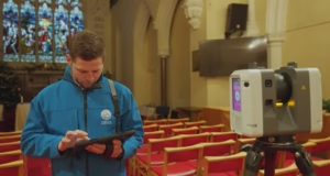
Step 2: On-Site Scanning
Here’s what happens on scan day:
- Our team shows up with scanners, tripods, tablets, and targets.
- We establish survey control points (if geo-referencing is required).
- We move through the site placing the scanner in multiple positions — capturing 360° at each setup.
- In tight areas, we may do extra scans to avoid blind spots.
- Some scanners also capture panoramic photos — great if you want colourised point clouds or a virtual viewer.
- Throughout the process, we monitor quality live — making sure we’ve got full coverage before we pack up.
You might see us stick reflective targets on walls — these help stitch multiple scans together accurately.
And don’t worry: the laser is completely eye-safe and non-intrusive. Scanning often happens while other site work continues.
Step 3: Data Processing & Registration
Once scanning’s done, we get to work behind the scenes.
This includes:
- Merging (registering) all scan positions into one unified point cloud
- Cleaning the data (removing noise, cropping, filtering out people/ghosts, etc.)
- Aligning the data to control points or national grid (if required)
- Quality checks to verify measurements against known site values
This stage is where we turn raw data into a usable asset — and trust us, processing is just as critical as the fieldwork.
On complex sites, this step can take longer than the actual scanning — but it’s worth it.
Step 4: Turning Your Scan Into Deliverables
Once we’ve got a clean, registered point cloud — now we focus on what you actually need.
Here’s what that looks like.
Option 1: 2D Drawings (Plans, Elevations, Sections)
If you’re working in CAD, we can extract traditional line drawings directly from the scan.
How it works:
- We slice the point cloud at key levels
- Trace out walls, doors, windows, etc.
- Annotate with levels, dimensions, and details
- Deliver as AutoCAD files (DWG/DXF) or PDFs
Everything is based on measured data — not assumptions. That means fewer surprises later on site.
Option 2: 3D Models (Revit / BIM / IFC)
Need a full 3D model?
We’ll import the point cloud into Revit and build a parametric model that matches reality — every wall, column, beam, roofline, and even the quirks.
This is ideal if:
- You’re working in BIM
- You want to retrofit, extend, or repurpose a structure
- Coordination between disciplines is essential
We can deliver native Revit files or open formats like IFC. And yes — we’ll model to the Level of Detail (LOD) you actually need. No more, no less.

Option 3: Point Cloud Files (Raw Data)
If your team has the skills/software, you might just want the raw point cloud.
We’ll provide it in formats like:
- .E57
- .RCP (Autodesk)
- .LAS / .LAZ
- .PTS or .XYZ (if needed)
Fully cleaned and registered — ready to drop into your CAD, Revit, or cloud viewer.
Bonus: Interactive 3D Viewer
Not everyone has CAD software.
That’s why we offer web-based viewers (like Leica TruView or similar), where you can:
- Virtually walk through the scan
- Click to measure distances
- View high-res 360° images
- Annotate and share
Clients love this — especially stakeholders or teams who just need visual clarity without diving into drawings.
We tailor all deliverables to what you need — not a cookie-cutter package.
Step 5: Quality Checks & Handover
Once your drawings, models, or point cloud are ready — we don’t just hit “send” and walk away.
Here’s how we make sure you get exactly what you need.
Built-In Quality Control
Every deliverable goes through multiple internal checks:
- Cross-verification of dimensions against the original point cloud
- Spot checks against known site measurements (captured during scanning)
- Layer, scale, and coordinate system reviews — to make sure everything aligns with your workflow
We’re ISO 9001 certified — so QA isn’t just a box we tick. It’s baked into how we operate.
Clear, Actionable Handover
Once the deliverables pass QA, here’s what you get:
- Digital files via secure download (or USB if files are large)
- A summary report listing:
- File formats included
- Coordinate systems used
- Any survey control applied
- Notes on model detail or drawing assumptions
- Access to your viewer platform (if requested), with instructions
Everything is delivered in formats your design team can jump into immediately.
And if your team hits a snag — needs a different file format, or clarification on something — we’re available. You won’t be left hanging.
Ongoing Support (If You Need It)
We don’t just hand off the files and disappear.
We’re here if:
- Your architect has a question about wall alignment
- The structural team needs a section added
- You decide to model more later and need the full point cloud
Many clients reuse their scan data for future phases, retrofits, or maintenance planning. That’s the beauty of laser scanning — it’s not just a one-and-done.
That’s the full 3D scanning process — from planning to handover.
So, how much does it cost?
How Much Does a 3D Laser Scanning Survey Cost?
Here’s the short answer: it depends.
But don’t worry — I’ll break down what drives the cost, what’s worth paying for, and how to avoid overspending.
6 Key Factors That Affect Cost
1. Size and Complexity of the Site
Simple truth: more square metres = more scan positions = more time = higher cost.
But it’s not just size.
A small, complex site (tight spaces, detailed architecture, busy machinery) can take longer than a big open warehouse.
So complexity = cost, too.
2. Level of Detail (LoD) You Need
Want just a point cloud? That’s relatively cheap.
Need:
- A Revit model of every pipe and duct?
- Elevations with full stone detailing?
- Linework for every roof tile?
That takes time — and skilled technicians. The more detail, the more investment. Tip: Be clear about what you actually need. Don’t pay for ultra-high detail if 2D plans will do the job.
3. Site Conditions and Accessibility
Here’s where logistics can bump up the price:
- Restricted hours? (e.g. only scan at night)
- Hard-to-reach areas? (roofs, towers, plant rooms)
- Safety gear or permits needed? (rail sites, confined spaces)
All of that affects how many crew we send, what kit we use, and how long we’ll be there.
4. Location and Travel
If your site is local to the surveyor, travel is minimal.
But for remote or multi-day jobs, you may need to factor in:
- Accommodation
- Mileage
- Extra mobilisation costs
We try to group jobs regionally when possible — and we’ll always keep this transparent.
5. Processing and Output Time
Some clients just want the scan. Others want full BIM models, drawings, or multiple formats.
Deliverables can be more time-consuming than fieldwork — especially if models need to hit specific standards (like LOD 3 in Revit or IFC export for a contractor).
Again: know your goals upfront.
6. Urgency
Need it tomorrow? Rush processing often requires out-of-hours work and extra resource allocation.
We can accommodate tight deadlines — just expect that to reflect in the quote.
Next, I’ll break down rough price ranges and give tips to manage costs.
What Does a 3D Laser Scanning Survey Actually Cost?
Every project is different, but here’s a rough idea based on typical UK pricing:
Small Projects
Think: a residential home, single shop unit, or small office.
- Fieldwork: Half a day
- Deliverables: 2D floor plans or a basic point cloud
- Typical cost: Low hundreds to low thousands
Medium Projects
Think: multi-storey buildings, moderate industrial units, or schools.
- Fieldwork: 1–2 days
- Deliverables: Point cloud, 2D drawings, maybe a Revit model
- Typical cost: £2,000–£5,000+
Large & Complex Projects
Think: hospitals, heritage sites, big factories, or campuses.
- Fieldwork: 3+ days, possibly multiple technicians
- Deliverables: Full BIM model, elevations, sections, topographic data
- Typical cost: £5,000–£20,000+
And yes — for massive jobs (think airports, stadiums, full campuses) — costs can scale even higher.
But you’re not paying for “just some dots.” You’re buying accuracy, risk reduction, and future-proofing.
How to Keep Costs Under Control
- Know your deliverables.
Don’t ask for a full BIM model if you only need floor plans for planning. Be specific about the level of detail you need to use, not just what sounds impressive. - Clear site access = faster work.
If the site is clutter-free, we can scan more efficiently. Delays = more time = more cost. - Bundle surveys if you can.
Need a topographic survey, utility mapping, and a building scan? Get them done together. Mobilising once is cheaper than calling three firms. - Be realistic with timeframes.
If your deadline allows us to schedule efficiently, we can usually offer better pricing. - Ask questions.
A good surveyor will advise if scanning is the right method — or if a cheaper alternative (like a traditional topo survey) might be enough.
Why You Should Hire a Professional for 3D Laser Scanning (Not Just Grab a Scanner Yourself)
Sure, tech’s getting cheaper. You’ve seen apps or handheld scanners that promise 3D scans “in minutes.”
So… can’t you just rent a scanner or buy a gadget?
Technically, yes. But here’s why that’s usually a bad idea when accuracy matters.
1. Tools Are Only as Good as the Operator
A £60,000 scanner is powerful — but useless in the wrong hands.
Certifed surveyors know:
- Where to place the scanner for best coverage
- How to account for reflections, line-of-sight issues, or movement
- How to align scans correctly (registration can get messy fast)
- What features matter for your project — not just “capture everything and hope”
We’re trained in geometry, measurement science, and practical surveying — not just pushing buttons.
2. Processing Takes Skill (and Power)
Even if you capture a scan, what next?
- Can you register 100+ scans without alignment errors?
- Do you have a workstation that can handle billions of points?
- Can you QA the final output so your architect isn’t working off skewed geometry?
It’s not just about “getting the data” — it’s about delivering clean, reliable outputs that actually drive design decisions.
3. Professional Equipment Is Next-Level
Top-tier scanners (like the Leica RTC360) can:
- Capture 2 million points per second
- Deliver ±2mm accuracy
- Auto-register scans on-site
- Add colour with onboard HDR cameras
These tools aren’t cheap. You’re not just renting tech — you’re hiring precision.
4. We Know How Your Project Team Works
Need your point cloud tied to the Ordnance Survey grid?
Want drawings in DWG or Revit files that drop right into your BIM model?
Need site control to match a previous topo?
We’ve done it all — and we speak the same language as your architect, contractor, or engineer.
5. You Get Peace of Mind (and Accountability)
Professional surveyors:
- Carry full insurance
- Follow regulated QA procedures
- Are part of national associations (like TSA or CICES)
- Stake their reputation on accurate data
If something goes wrong, you’ve got backup — not just a DIY scan you hope is right. If your decisions (or your design) depend on correct data — get it done by a pro.
Why Choose Terrain Surveys for Your 3D Laser Scanning Project?
There are plenty of survey companies out there. So why work with Terrain Surveys?
Here’s what sets us apart — and why clients keep coming back.
1. 20+ Years of Experience
We’ve been doing this since 2004. Thousands of successful surveys later, we’ve seen:
- Tight basement plant rooms
- Wonky medieval rooflines
- Entire London office blocks
- Full cathedral interiors (yep — including the triforium!)
When you hire us, you get a team that’s seen it all — and delivered every time.
2. Cutting-Edge Equipment
We invest heavily in top-tier gear:
- High-speed Leica and FARO scanners
- Drone and UAV options (when needed)
- Powerful software (Cyclone, ReCap, Revit, AutoCAD)
No rental kit. No hand-me-down tech. You get the best tools, operated by the best pros.
3. Qualified, Accredited, and Safe
We’re:
- Members of The Survey Association (TSA)
- ISO 9001 certified (quality you can trust)
- Constructionline Gold accredited
- Trained for rail, confined spaces, and more
All our surveyors hold CSCS cards. And safety? Always non-negotiable.
4. One-Stop Surveying
Need more than just scanning? We also provide:
- Topographical surveys
- Underground utility surveys (PAS128)
- Area measurement surveys
- Monitoring & deformation checks
We can bundle services together to save time and streamline delivery.
5. Client-First Mentality
From first contact to final handover — we’re here to help, not upsell.
We:
- Answer questions in plain English
- Deliver clear quotes (no surprises)
- Offer tailored advice — even if it means recommending a simpler survey method
Our job is to get you the right data for your project — not just throw tech at it.
Ready to Talk?
Whether you’ve got a complex retrofit, a heritage restoration, or just want to future-proof your site survey — we’d love to help.
Send an enquiry via our website.
We’ll get back quickly with honest advice, and if needed, a tailored quote.
No pressure. No jargon. Just expert help from a team that lives and breathes accurate data.


