3D laser scanning has completely revolutionised how we capture building data.
But here is the thing.
The first question we are always asked by clients – whether they are architects, property developers, or homeowners – is the same:
“How much does a 3D point cloud survey actually cost?”
And whilst that is a perfectly reasonable question, it is not possible to answer without knowing what is needed. It is very much like asking a car dealership how much a car costs without telling them which car.
Here is some context.
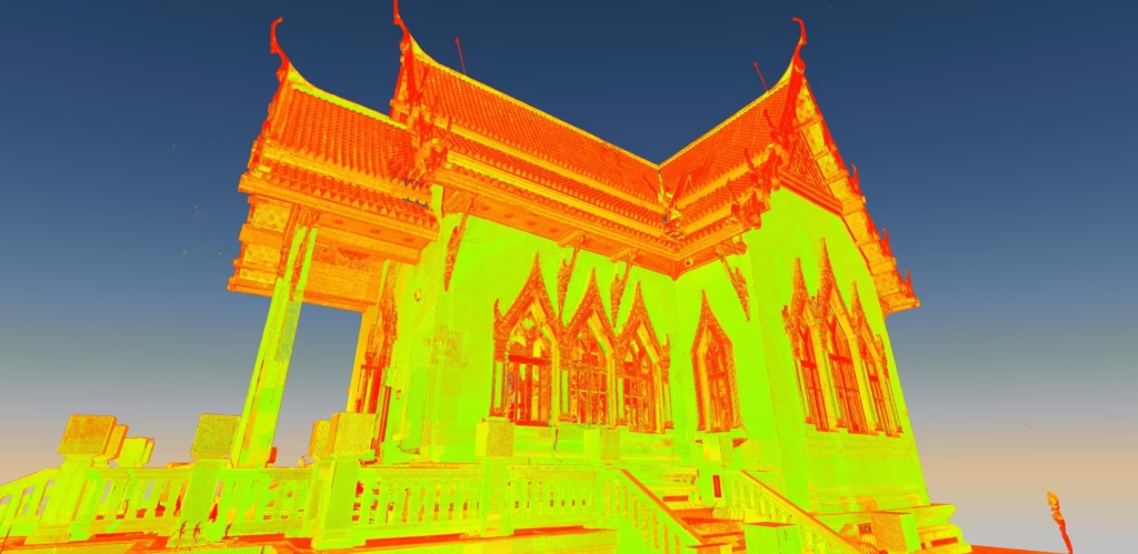
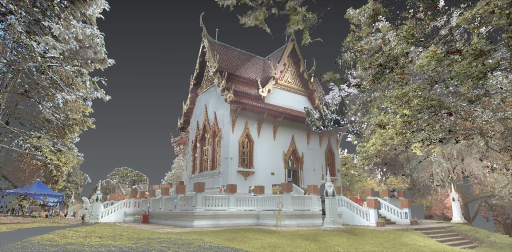
A point cloud survey gives you millions of data points that capture your physical space with millimetre accuracy. It is brilliant technology. But what most people do not realise is that the initial survey cost is just the beginning.
The true cost lies in what you do with all that data afterwards.
And that is where things might get a bit more expensive.
Terrain Surveys completes over 1,000 point cloud surveys across the UK every year, working with architects, developers, and heritage bodies on everything from listed buildings to large commercial sites. We work to RICS guidelines and the UK BIM Framework across all our deliverables.
How Much Does the Survey Actually Cost?
Let us start with the basics – what you will actually pay for the survey itself.
The Price Brackets
Across the UK, here is what you can typically expect to pay:
| Property Type | Typical Scope | Indicative Cost |
|---|---|---|
| Small Residential (3-4 bed house) | Internal and external capture, basic feature survey | £600 – £1,200 + VAT |
| Medium Commercial / Industrial (office block, small warehouse) | Full internal capture, structural elements, services | £1,500 – £3,500 + VAT |
| Large / Complex Sites (heritage buildings, large campuses) | Multi-storey, restricted access, high detail requirements | £4,000 – £10,000+ + VAT |
But here is what those numbers do not tell you.
Several variables can push costs up or down. Site location matters. Access restrictions matter. The level of detail you need matters. Whether the building is occupied matters. So does whether you need only the raw point cloud data, or you want it converted into a usable model.
What many people do not realise is that building layout is often the single biggest driver of cost variation – more so than building size. As surveyors, we need to measure every aspect of a building to provide a fully accurate survey of what exists; we cannot make assumptions. That means accessing every room and every nook and cranny, so the more divided a space is, the longer it takes to survey.
A modern open-plan office can be surveyed rapidly thanks to large open areas and clear lines of sight (laser scanners work on the line-of-sight principle – they can only measure what can be seen from a specific point, so any obstruction limits what can be captured from a single set-up). Conversely, a basement carved up into small rooms with cubby holes and winding corridors can take up to five times as long to survey as an open-plan office of the same floor area.
A city centre office with restricted access and people working inside? That is going to cost more than an empty warehouse in the countryside.
Our Approach at Terrain Surveys
We do not do “one-size-fits-all” pricing.
Never have. Never will.
When clients come to us, we tailor the quote to the exact needs of the project. Why should you pay for unnecessary data? You should not.
If you are renovating a Victorian terrace, you do not need the same level of detail as someone modelling every service route in an office block.
That is just common sense.
Based on twenty-five years in land and building surveying, my view is that the single biggest mistake clients make when commissioning a point cloud survey is being tempted by the lowest price. Whilst this may look like a sensible saving at the outset, it is almost always a false economy.
Advances in scanning technology have made data capture faster, more affordable, and easier to operate. That is the upside. The downside is that it has opened the door to operators with little or no surveying background. The equipment may be impressive, but pressing buttons is not the same as understanding surveying – specifically, robust survey control.
If there is one piece of advice I would urge anyone procuring point cloud or any other geospatial data to follow, it is this: ask the provider about the survey control network they will use. If they cannot give you a clear answer, walk away.
A high-quality point cloud survey starts with robust survey control. It is the foundation everything else relies on. If the control is poorly designed or misunderstood, the data may look fine on screen but will not be reliable in the real world. Errors may not be obvious at first, but they tend to surface later – during design coordination, construction, or when multiple datasets are brought together.

Software can automate calculations and scanners can collect millions of points, but they cannot replace the fundamentals of surveying. If the person capturing the data does not understand what is happening behind the screen, accuracy cannot be guaranteed.
In surveying, the old rule still applies: rubbish in, rubbish out. Choosing a competent, experienced surveyor is not just about better data; it is about reducing risk, avoiding rework, and protecting the integrity of your project from the start.
Getting it right the first time also saves thousands in rework later in your project. We recently worked with an architect on the conversion of a Grade II listed mill. One of the central challenges was accessing the roof spaces: the hatches were tight to get through and the stability of the flooring was questionable, yet the information was critical to the design.
To overcome the access and safety issues, we used an extending tripod to raise our 3D laser scanner into the roof void and operated it remotely from the safety of the floor below. That gave us complete data capture of the target property, roof voids included, from which we produced a detailed LOD3 Revit model – allowing our client to progress designs and consultation with confidence.
Where clients come to us after a failed or insufficient survey by another provider, the average cost of remediation – covering emergency resurveys, contractor delays, and rework – has been roughly ten times the original survey cost.
A few hundred pounds saved on the survey stage. Thousands lost further down the line.
The Hidden Costs – Time, Tech, and Training
Now let us talk about what happens after the survey.
This is where things get properly expensive.
The Reality Check
Picture this: your surveyor hands you a USB drive. On it? Your point cloud data. Hundreds of gigabytes of raw information.
You plug it into your office computer.
Nothing happens.
Actually, that is not true. Your computer crashes.
Welcome to the world of point cloud processing.
Hardware and Software Requirements
To even open these files, you need serious kit.
Software licences are not cheap. The Autodesk AEC Collection – which includes Revit and ReCap Pro – runs at around £3,000+ per year. Per user.
And that is just the software.
Hardware requirements are equally demanding. You are looking at high-end workstations with a minimum of 32GB-64GB RAM and top-tier graphics cards. Budget £2,000-£4,000+ per machine.
Your standard office laptop will not cope.
The Learning Curve Nobody Talks About
Here is what software vendors will not tell you.
In our experience training CAD users internally and watching clients attempt to handle their own point cloud data, it typically takes a minimum of three to six months of daily, dedicated use before someone becomes genuinely proficient – able to register, clean, and model from raw data without significant errors.
Six months.
And that is assuming consistent daily use.
Based on our experience processing data from more than 8,000 projects, we typically spend around half an hour post-processing scan data for every hour on site. For complex heritage structures, that ratio can rise to as much as 1:1.

Post-processing time varies depending on site conditions, specification, and deliverables – but it is rarely as quick as people expect. If you do not know what you are doing? Double those numbers. At least.
To architects and engineers reading this: your time is best spent designing and managing projects – not spending weeks learning how to clean up point cloud noise, not struggling to convert millions of data points into usable 3D models. That is not what your clients admire you for.
The Smart Alternative – Hiring a Revit Technician
So what is the solution?
It is simpler than you might think.
The Cost-Effective Route
Instead of buying expensive software, upgrading your entire IT infrastructure, and spending months training your staff, there is a better way.
Hire a Revit technician, or better yet, ask our in-house team of UK-based Revit specialists to handle the modelling end to end.
Why This Approach Works
Speed
A dedicated technician turns point clouds into accurate 2D plans or 3D models in a fraction of the time. What might take your team weeks, they will complete in days.
Why? Because they do this every single day.
Cost-Efficiency
You only pay for the final, usable deliverable. The Revit model. The CAD drawings. The output you can actually work with.
No software subscriptions eating into your monthly overheads. No training downtime whilst your team gets up to speed. No expensive hardware gathering dust between projects.
Accuracy
This may be the most important advantage.
We know how to interpret point cloud data correctly. Our approach to point cloud registration and cleaning involves five key quality checks we have developed over many years. The step most firms skip – and the one that causes the most downstream problems – is cleaning the raw data. This stage strips out the noise generated during scanning, before registration takes place.

We have made it mandatory on every project, because if spurious data is left in place it can introduce registration errors that ultimately translate into inaccuracies in the dataset.
We also understand how to model existing conditions whilst accounting for construction tolerances, and we ensure every deliverable aligns with the UK BIM Framework and RICS standards.
This is not guesswork. It is expertise developed across thousands of projects.
Who Benefits From This Approach?
In our experience, almost everyone.
A homeowner needing simple 2D elevations for a planning application? Outsourcing the modelling makes sense.
A conservation architect working on a complex refurbishment of a listed building under Historic England guidelines? It also makes sense.
Unless you are processing point clouds on a weekly basis, the investment in infrastructure and training simply does not add up.
The Bottom Line
Let me be clear about something.
A 3D point cloud survey is an invaluable investment. The accuracy, the detail, the peace of mind it provides – all worth every penny.
But you must factor in the processing.
Raw point cloud data is like crude oil. Valuable, yes. But useless until it is refined into something you can actually use.
And that refining process? That is where most projects hit a wall.
What Makes Us Different
At Terrain Surveys, we do not just hand you a massive file and wish you luck.
That is not how we work.
We provide finished, ready-to-use Revit models or CAD drawings – the deliverables you need to actually move your project forward. Before we begin, we find out what you need and what the objective is, and then we deliver exactly that.
The feedback we hear most consistently from architects and project managers is that they really appreciate our responsiveness and clarity of communication. What they value most, in our experience, is not just the accuracy of the data but the fact that whenever they have a question, there is someone available to answer it – whether that means confirming receipt of an email, making access arrangements, discussing survey requirements or deliverables, or anything in between.
No wrestling with software you do not understand. No watching YouTube tutorials at midnight trying to work out why your point cloud will not register properly. No explaining to your client why the modelling is taking three times longer than expected.
Just clean, accurate, professional deliverables. Ready to use fast.
The Financial Reality
Think about it this way.
Option one: Spend £3,000+ on software, £4,000+ on hardware, lose months of productivity whilst your team learns the ropes, and still risk getting it wrong.
Option two: Pay for exactly what you need – a professional survey and the finished models – and get on with what you do best.
It is not even close.
Your Next Step
For free professional advice and a no-obligation quote, please reach out to our team today via our Terrain Surveys contact page.
We will talk through your project, explain exactly what is involved, and give you a clear picture of both the costs and the deliverables. No obligation.
No surprises. No hidden fees. No massive files you cannot open.
Just the data you need, in the format you need it, when you need it.