The Value of a One-Stop Survey Provider: Saving Time, Reducing Costs, and Improving Project Clarity
In the construction and property sectors, precise, timely, and well-coordinated survey data is fundamental to successful project delivery. From feasibility assessments to final handover, different types of surveys provide the crucial spatial and underground intelligence needed at each phase. However, when these services are sourced from multiple companies, the benefits of efficiency and integration are often lost. At Terrain Surveys, we’ve seen first-hand how offering a comprehensive, end-to-end surveying service brings clarity, control, and cost savings to projects of all sizes.
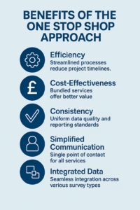
Multiple Survey Types, One Source of Truth
A typical development may require a combination of measured building surveys, topographical surveys, utility and drainage surveys, CCTV inspections, laser scanning, and Revit modelling. These surveys aren’t isolated tasks—they feed into one another. For example, an accurate topographical survey can inform a utility survey, and both datasets may be vital inputs to a 3D Revit model or BIM environment.
When a single provider manages these surveys, the interdependencies are understood from the outset. There’s no need for repeated site visits, duplicated effort, or stitching together mismatched datasets. Our team collaborates internally across disciplines, ensuring that each survey complements the others and contributes to a coherent whole.
Smarter Logistics, Fewer Delays
Project timelines often suffer when coordination is left to chance. Bringing in multiple suppliers means juggling different availability, lead times, reporting formats, and quality standards. The risks increase when surveys must be done in a specific order or under unique constraints—like a night-time utility survey on a busy main road, or working around public access near landmarks like Trafalgar Square.
By contrast, Terrain Surveys can plan and phase all required survey activities in-house, streamlining the timeline and reducing downtime. We understand the sequencing of survey work, the permit requirements, and how to ensure safe, compliant access to complex sites. Our clients benefit from a consistent point of contact and a unified project plan.
Real-World Impact: Cost, Clarity, and Confidence
We’ve seen how fragmented survey procurement can lead to overlapping scopes, conflicting results, or expensive on-site clashes. For example, if a utility survey is carried out without reference to an up-to-date topographical base, discrepancies can cause rework or design errors. Conversely, our integrated approach ensures that all outputs are accurate, aligned, and delivered in compatible formats that feed directly into design and planning workflows.
Architects, developers, and project managers working with Terrain Surveys gain more than just survey data—they gain confidence. Confidence that the surveys are coordinated, that insights are shared across disciplines, and that no time or money is wasted on preventable mistakes.
Your Partner from Below Ground Level to Rooftop
Whether it’s scanning the façade of a historic structure, modelling retail units in Revit, or tracing buried utilities beneath a busy road, Terrain Surveys has the expertise and equipment to deliver. By bringing all your survey needs under one roof, we make your projects smoother, faster, and more cost-effective.
At Terrain Surveys we provide an comprehensive, integrated and expert-led approach to all survey types. Contact us today to discuss your upcoming project.