Roof inspections are essential for property maintenance, development, and safety. Yet traditional methods are notoriously difficult, dangerous, and expensive.
Think about it. Working at height remains one of the biggest causes of workplace fatalities in the UK. The costs of scaffolding and cherry pickers can quickly spiral into thousands. And the disruption to your business operations or home life? That’s another headache entirely.
Not to mention those hard-to-reach areas that often get missed during manual inspections.
As a company committed to investing in the latest technological advances, we’ve seen first-hand how drone technology has revolutionised this process. A drone roof survey offers a safer, faster, and more comprehensive solution.
In this guide, we’ll explain what a drone roof survey is, how the process works, and the key benefits for your specific project.
What Exactly Is a Drone Roof Survey?
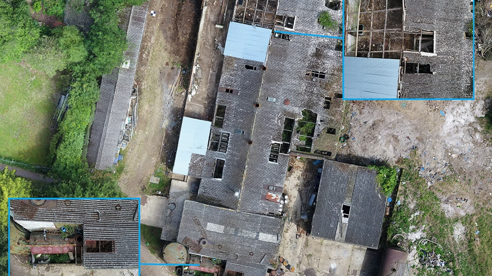
Simply put, a drone roof survey uses an Unmanned Aerial Vehicle (UAV) equipped with high-resolution cameras to capture detailed images and data of a roof structure.
All without anyone needing to leave the ground.
But it’s far more sophisticated than just flying a camera about. Our drones carry high-resolution
cameras that capture crystal-clear visual data. These allow us to spot minor defects like cracked tiles or failing flashing that might otherwise go unnoticed.
Here’s what sets professional drone surveys apart:
The data captured is far more than just a few photos. We process everything to create:
- Comprehensive, geotagged images – Every image is precisely located, making it easy to identify exactly where issues are.
- Orthomosaic maps – A single, high-resolution, top-down image of your entire roof, stitched together from hundreds of photos.
- 3D models and point clouds – Highly accurate digital replicas of your building, perfect for architects and engineers to use in CAD or BIM software.
- 2D CAD plans – Accurate 2D plans issued in DWG format, which can be coordinated into an existing measured building survey to provide a complete picture of your property – No more estimating roof extents/gradients and structures due to restricted lines of sight encountered by traditional survey methods, the drone survey will remove the guess work.
This isn’t your neighbour’s hobby drone taking a few HD snaps. This is professional-grade surveying technology delivering actionable data. Our drones can be equipped with Lidar scanners, thermal imaging, or other specialist tech that provides highly accurate data that professionals, like architects, engineers, planning authorities, and builders can rely on to make real-life decisions that affect outcomes.
How It Works: Our Process from Start to Finish
Let me walk you through exactly how we conduct a drone roof survey at Terrain Surveys. No smoke and mirrors – just a clear, professional process.
Step 1: Initial Consultation & Scoping
It all starts with a conversation.
You tell us what you need. Whether it’s a general condition report for your annual maintenance schedule or detailed data for a major refurbishment project. We listen, ask the right questions, and provide free, expert advice.
Then we’ll give you a clear, no-obligation quote. No hidden fees. No surprises.
Step 2: Pre-Flight Planning & Risk Assessment

Safety and compliance are paramount.
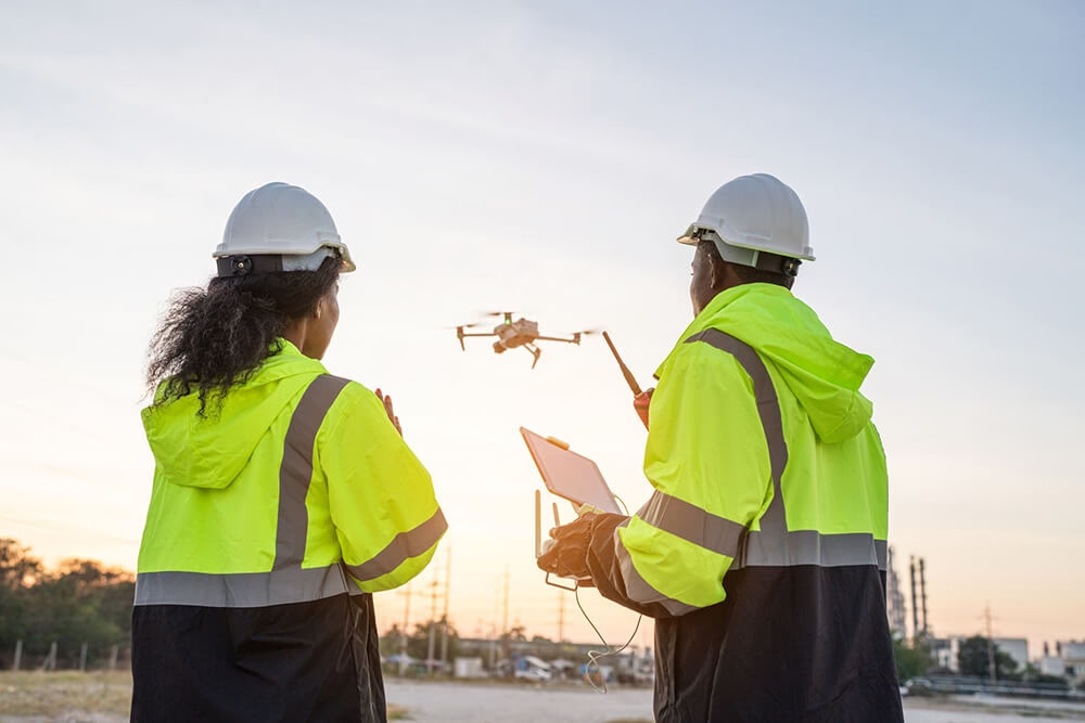
Our qualified pilots conduct a thorough pre-flight assessment before every survey. This includes checking airspace regulations with the Civil Aviation Authority (CAA), assessing ground risks, and planning the optimal flight path.
We leave nothing to chance. Every flight is meticulously planned to ensure a safe and efficient survey.
Step 3: The On-Site Survey
On the day, our team arrives and can be ready to fly in minutes.
The flight itself is remarkably quick. Even for large or complex roofs, we’re often done in less than an hour. Compare that to the days it might take to erect scaffolding or conduct a manual inspection.
We cause minimal disruption to your site, business, or home. Your operations continue as normal whilst we gather the data you need.
Step 4: Data Processing & Analysis
Back at the office, the real magic happens.
Our expert surveyors process the captured data, turning raw images into valuable assets.
Whether you need a detailed defect report highlighting every issue or a precise 3D model for your renovation plans, this is where we create it.
Every piece of data is checked, verified, and prepared to the highest professional standards set out by our governing bodies.
Step 5: Delivery of Your Report
You receive a clear, actionable report tailored to your requirements.
This typically includes annotated photographs highlighting any issues, a written summary of the roof’s condition, and links to digital models or datasets. Everything is presented in a format that’s easy to understand and act upon.
No technical jargon. Just clear information you can use.
The Key Benefits of a Drone Roof Survey
Let’s get straight to what matters most to you.
Drone roof surveys deliver four core advantages: they’re safer, faster, more cost-effective, and provide better data than traditional methods.
Benefit 1: Unmatched Safety
This is the big one.
Drone surveys eliminate the need for working at height, directly addressing the biggest risk in roof work. According to the Health and Safety Executive, falls from height accounted for nearly 30% of all fatal injuries to workers in recent years.
That’s a sobering statistic.
By keeping everyone firmly on the ground, drone surveys comply with the Work at Height Regulations 2005 whilst removing the human risk factor entirely. Your team stays safe. Your contractors stay safe. And you avoid the liability concerns that come with traditional roof access methods.
It’s a no-brainer, really.
Benefit 2: Significant Cost Savings
Let’s talk money.
The cost of scaffolding for a typical semi-detached house can easily exceed £1,000. And that’s before a single person has even stepped onto the roof. For larger commercial buildings? You’re looking at tens of thousands.
A drone survey? It’s a fraction of this cost.
You also eliminate expenses for:
- Mobile elevated work platforms (MEWPs)
- Rope access teams
- Safety equipment hire
- Multiple site visits
- Extended labour costs
The savings are immediate and substantial. Money you can invest elsewhere in your property or project.
Benefit 3: Speed and Minimal Disruption
Time is money. And drone surveys save you both.
What takes a team a full day to inspect manually can often be surveyed by a drone in under an hour. That’s not an exaggeration – it’s the reality of modern surveying technology.
For businesses and facilities managers: This means no operational downtime. Your warehouse keeps shipping. Your office keeps working. Your retail space stays open.
For homeowners: It means minimal intrusion. No scaffolding blocking your windows for days. No strangers tramping through your garden. Just a quick, professional survey with results delivered promptly.
Benefit 4: Comprehensive & Actionable Data

Here’s where drone surveys truly shine.
Drones capture the entire roof area from multiple angles, leaving no stone (or tile) unturned. Every valley, every ridge, every potential problem area is documented in high resolution.
For Architects and Engineers: The point cloud data we generate provides accurate measurements for your designs and BIM models. Import it directly into your CAD software and start designing immediately.
For Facilities Managers: The high-resolution imagery is perfect for creating a visual record for planned preventative maintenance (PPM). It’s also invaluable for verifying storm damage for insurance claims – insurers love the clarity and detail our reports provide.
The data isn’t just comprehensive. It’s actionable. You can make informed decisions based on facts, not guesswork.
Who Needs a Drone Roof Survey?
Let me speak directly to you, depending on your specific needs.
For Architects & Engineers
You need precise as-built data for refurbishment and conservation projects.
Our 3D models, 2D CAd drawings and orthomosaics can be imported directly into your design software, saving you countless hours of manual measurement. No more climbing up with a tape measure. No more estimating dimensions from old drawings.
You get fresh, accurate, current data that forms the foundation of your design work.
For Property Developers
Due diligence is everything in property development.
Use drone surveys before acquiring a new site to understand exactly what you’re buying.
Monitor construction progress without disrupting work on the ground. Create compelling marketing visuals of completed projects that showcase your development from angles impossible to capture otherwise.
It’s an essential tool in your development toolkit.
For Facilities & Estate Managers
This is a game-changer for planned preventative maintenance.
Quickly and affordably survey your entire property portfolio. Identify potential issues before they become costly problems. Get definitive evidence for insurance claims that speeds up the process and ensures fair settlements.
Managing multiple properties? You can survey them all in the time it would take to manually inspect just one.
For Homeowners
Whether you’re buying a new home and want to check the roof, concerned about a leak, or need to assess storm damage, a drone survey is the safest and most affordable way to get a clear and honest assessment.
No daunting scaffolding costs. No risky ladder work. Just professional, detailed information about your most important investment – your home.
The Bottom Line
As you can see, drone roof surveys have moved from niche technology to an essential tool for anyone responsible for a building’s integrity.
They offer a solution that is safer, more affordable, and provides better data than traditional methods ever could.
At Terrain Surveys, our commitment is to provide you not just with data, but with actionable insights, underpinned by our dedication to quality and safety. Our ISO 9001 and Constructionline Gold accreditations demonstrate our commitment to the highest professional standards. We’re not just flying drones; we’re delivering professional surveying solutions that solve real problems.
If you’re planning a project, managing a property, or simply need peace of mind about the state of your roof, our team is here to help. We provide free, no-obligation quotes and professional advice to ensure you get the right survey for your needs.
Contact our expert team today.