In an age where your phone can manage your life, navigate your car, and even identify plants, it’s a fair question to ask: can it accurately survey your land?
We get it.
You’re looking at your property, perhaps planning an extension or settling a boundary question, and you’re wondering if that powerful device in your pocket could save you time and money. After all, there’s an app for everything these days, right?
Here’s our honest take on what smartphone apps can do, and more importantly, where their limitations lie.
The Rise of Surveying Apps: What Can They Actually Do?
Let’s start with what’s possible.
Modern smartphones are remarkable pieces of technology. They pack GPS receivers, high-resolution cameras, accelerometers, gyroscopes, and on newer models, even LiDAR sensors. Naturally, app developers have tried to harness this technology for surveying purposes.
Browse your app store and you’ll find dozens of apps claiming to measure land, calculate areas, and even create site maps.
These apps generally fall into a few categories:
- GPS Plotting Apps allow you to walk around your property boundary whilst the app tracks your movement via GPS. Once you’ve completed the circuit, it calculates the enclosed area.
- Satellite Measurement Tools let you trace boundaries on a satellite image, much like drawing on Google Earth. The app then calculates the area of your drawn shape.
- Basic Levelling Functions use your phone’s internal sensors to act as a digital spirit level, helping you check if surfaces are flat or measure rough angles.
- Camera-Based Measurement apps use your phone’s camera and augmented reality to estimate distances and heights of objects in view.
Now, let’s be balanced here.
For certain non-critical DIY projects, these apps can be genuinely useful. Planning where to place a new garden shed? Estimating how much turf you need for that new lawn? For these simple tasks, a rough measurement is often all that’s required, and a smartphone app might do the job.
But here’s where we need to draw a crucial line.
The moment your measurements matter legally, financially, or structurally, you’ve moved beyond what smartphone technology can reliably deliver.
For this reason, most apps have legal disclaimers buried in their terms and conditions. Because the developers know the apps aren’t good enough for real land surveys, and they don’t want to be sued by someone who uses them for that purpose.
The Critical Limitations: Why Your Smartphone Isn’t a Professional Survey Instrument
This is where we need to get technical. Not to blind you with science, but to explain why the gap between consumer technology and professional surveying equipment isn’t just significant – it’s a chasm.
Inaccurate GPS: The 5-Metre Problem
Your smartphone’s GPS is typically accurate to 3-5 metres in open areas.
Read that again. Three to five metres.
Near buildings, under tree cover, or in urban areas with tall structures? That accuracy drops to 10 metres or worse. The GPS chip in your phone was designed to get you to the right street, not to define legal boundaries or position building foundations.
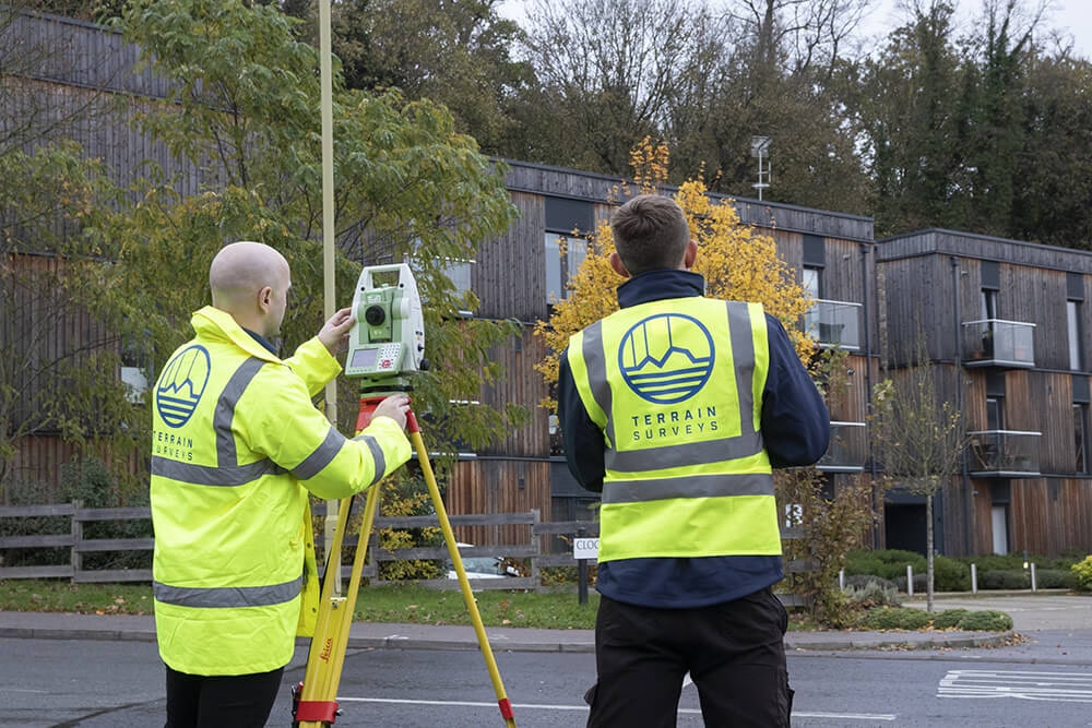
Professional surveyors use GNSS equipment (Global Navigation Satellite Systems). Our receivers connect to networks of fixed base stations, using a technique called Real-Time Kinematic positioning. The result? Sub-centimetre accuracy.
Think about it this way: smartphone GPS is the difference between knowing which street your car is on versus knowing exactly which parking bay it’s in. When you’re dealing with boundary disputes where every centimetre counts, that difference isn’t just important – it’s everything.
No Connection to the Ordnance Survey Grid
Here’s something most people don’t realise.
Every professional survey in the UK must be tied to the Ordnance Survey National Grid. This isn’t just best practice – it’s a legal and planning requirement. Your local authority won’t accept plans that aren’t properly georeferenced. HM Land Registry requires it for boundary determinations. Your architect needs it.
Smartphone apps? Their data floats in isolation. It exists in its own little universe, disconnected from the national coordinate system that underpins all official mapping in Britain. It’s like trying to use Monopoly money to pay your mortgage – it might look similar, but it has no legal standing.
No Reliable Height or Level Data
A phone cannot replicate the function of a calibrated Total Station or 3D Laser Scanner.
Why does this matter?
Because land isn’t flat. Even sites that look level to the naked eye, it may have subtle variations that profoundly impact drainage, foundations, and construction costs. We regularly survey sites where a variation of just 50mm across a building footprint would cause significant structural issues if not properly addressed.
Professional equipment measures levels to millimetre accuracy. This precision is critical for drainage design, flood risk assessment, and setting foundation levels. A few centimetres of error here could cost tens of thousands to rectify.
Legal Standing: The Data Nobody Accepts
Let’s be blunt.
The data produced by smartphone apps has no professional certification. No local authority will accept it. No solicitor will use it for boundary determinations. No architect will base their designs on it.
This isn’t bureaucracy for bureaucracy’s sake. It’s about accountability and standards.
Professional surveyors like us are members of recognised bodies such as The Survey Association (TSA). We’re ISO 9001 accredited. Our work is insured, verified, and produced to widely recognised UK industry standards.
When we sign off on a survey, we’re putting our professional reputation on the line. That signature means the data can be relied upon for critical decisions.
A smartphone app?
It comes with a disclaimer absolving the developer of any responsibility.
Real-World Consequences: When Smartphone Surveying Goes Wrong
We were once called to a site where a homeowner had used a smartphone app to measure their garden before commissioning an expensive landscaping project. The app showed they had 400 square metres to work with. The landscapers ordered materials and hired equipment.
The actual area? 310 square metres.
That’s not a small discrepancy – it’s nearly 25% less than expected. The project had to be completely redesigned, materials were returned, and the budget was blown before work even started.
In another case, a landowner used smartphone GPS to position a new barn. They were two metres over the boundary. The neighbour noticed when foundations were being dug. Legal proceedings followed. The foundations had to be demolished and repositioned. The costs ran into six figures.
These aren’t isolated incidents. We regularly resurvey sites where smartphone data has led people astray.
What a Professional Survey Delivers

So, what do you get when you hire a professional?
The Right Tools and Expertise
We use a combination of specialist equipment that costs tens of thousands of pounds, not a £1000 iPhone. If an iPhone could do the job we’d save an absolute fortune in equipment. Unfortunately, it doesn’t.
- Our Topographical Surveys use 3D Laser Scanners, drones and Total Stations to create highly accurate 3D maps of your site, capturing every tree, manhole, and change in level.
- For building projects, our Measured Building Surveys use laser scanners to provide precise internal and external data architects need for refurbishment and planning.
- And before you dig, our Underground Utility Surveys use Ground Penetrating Radar (GPR) to map hidden pipes and cables, preventing dangerous and costly strikes.
The Deliverables That Drive Projects
The output isn’t a screenshot. It’s a professional-grade digital file – a 2D CAD drawing or a 3D Revit model – that integrates seamlessly with your architect’s and engineer’s software.
This data becomes the single source of truth for your entire project. Get it right at the start, and you prevent errors from cascading down the line.
Use the Right Tool for the Right Job
Your smartphone is a remarkable device. But it’s not a professional survey instrument.
The moment accuracy matters – when legal boundaries need defining, when buildings need designing, when construction needs planning – the limitations of smartphone technology become deal-breakers.
Investing in a professional survey isn’t a cost; it’s insurance against expensive errors, delays, and legal issues.
Get Professional Advice – It’s Free
If you’re an architect planning an extension, a developer assessing a site, or a homeowner needing to confirm a boundary, your smartphone is not the answer.
Our team at Terrain Surveys is here to provide free, professional advice on the type of survey your project needs. We’ll guide you through the options and provide a clear, no-obligation quote.
Don’t risk your project on smartphone guesswork. Ensure it’s built on a foundation of accuracy.
Get in touch with our expert team today to get it right the first time.