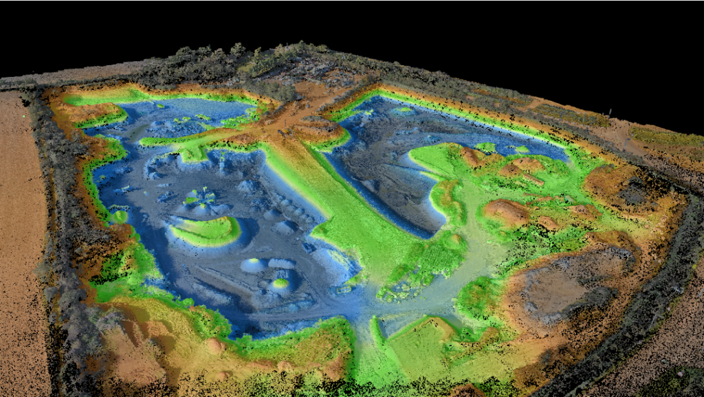
Topographical surveys are an essential tool in modern land surveying, providing accurate and detailed information about the physical features of a particular area of land. These surveys, also known as topographic surveys or topographical land surveys, involve the precise measurement and mapping of natural and man-made elements on the land’s surface. In this article, we will delve into the intricacies of topographical surveys, their importance, methods, and applications.
Importance of Topographical Surveys
Topographical surveys play a crucial role in a variety of fields, including civil engineering, urban planning, architecture, and environmental management. These surveys provide accurate data on the terrain’s shape, elevation, and features, which is vital for designing and planning various construction and development projects. Topographical surveys help identify potential issues such as slopes, drainage patterns, and existing structures, which can impact project design, feasibility, and safety. Accurate topographical data also aids in resource management, environmental impact assessment, and land-use planning.
Methods of Topographical Surveys
Topographical surveys are conducted using various methods and equipment, depending on the area’s size, complexity, and accuracy requirements. These methods typically involve precise measurements of points on the land’s surface, which are then used to create detailed maps and models. Some common methods used in topographical surveys include:
- Total Station Survey: Total stations are electronic surveying instruments that use a combination of electronic distance measurement (EDM) and angular measurements to determine precise coordinates of points on the land’s surface.
- Global Positioning System (GPS) Survey: GPS technology uses satellite signals to determine accurate positions on the Earth’s surface. GPS surveys can be used for large-scale topographical surveys, providing fast and accurate results.
- LiDAR (Light Detection and Ranging) Survey: LiDAR uses laser beams to measure distances and create high-resolution, three-dimensional (3D) models of the land’s surface. LiDAR surveys are especially useful for large-scale and complex topographical mapping, such as for aerial or underwater surveys.
- Photogrammetry: Photogrammetry uses aerial or ground-based photographs to create accurate topographical maps. Advanced software processes the images and generates precise 3D models.
Applications of Topographical Surveys
Topographical surveys have a wide range of applications across various industries. Some of the common applications include:
- Engineering and Construction: Topographical surveys are vital in engineering and construction projects, providing critical information for designing roads, bridges, buildings, pipelines, and other infrastructure. Accurate topographical data helps engineers and architects plan and design structures that are safe, efficient, and environmentally sustainable.
- Urban Planning: Topographical surveys assist urban planners in understanding the existing landscape and infrastructure to develop comprehensive plans for land use, transportation, and urban development. These surveys provide data on existing structures, vegetation, water bodies, and other features that impact urban planning decisions.
- Environmental Management: Topographical surveys are used in environmental management to assess the impact of development projects on the natural landscape, water resources, and ecosystems. These surveys help in identifying sensitive areas, mapping habitats, and planning conservation measures.
- Mapping and GIS: Topographical surveys are used in creating accurate and up-to-date maps for various purposes, such as navigation, land administration, and geographic information systems (GIS). Topographical data is used in GIS applications for spatial analysis, modeling, and decision-making.
The importance of topographical surveys cannot be overstated, as they contribute to the safe and efficient development of infrastructure, urban planning, and environmental conservation. Accurate topographical data enables professionals to make informed decisions, identify potential challenges, and develop sustainable solutions. With the advancement of technology, topographical surveys are becoming more precise, efficient, and accessible, allowing for better planning and management of land and resources.
For more information on topographical surveys contact Terrain Surveys
