Overview
Colchester Zoo first opened in 1963 and has since grown into one of the UK’s leading zoological attractions, drawing around a million visitors each year. Set within 60 acres of parkland and lakes, the zoo is home to over 150 different species – from Amur leopards and orangutans to Komodo dragons, sun bears, giraffes, lions, and many more.
Beyond its role as a visitor destination, Colchester Zoo plays a vital part in international conservation and breeding programmes, with its charitable arm, Action for the Wild, supporting projects around the world, including its own 6,000-hectare UmPhafa Reserve in South Africa.
In 2023, the zoo launched a long-term master plan that sets out ambitious improvements and expansions. This includes creating larger, more naturalistic habitats for elephants, lions, and orangutans, alongside new exhibits such as a gorilla house, a nocturnal house, and an expanded African savanna. These developments are designed not only to enhance visitor experience but also to strengthen the zoo’s contribution to education, animal welfare, and global conservation.
Survey
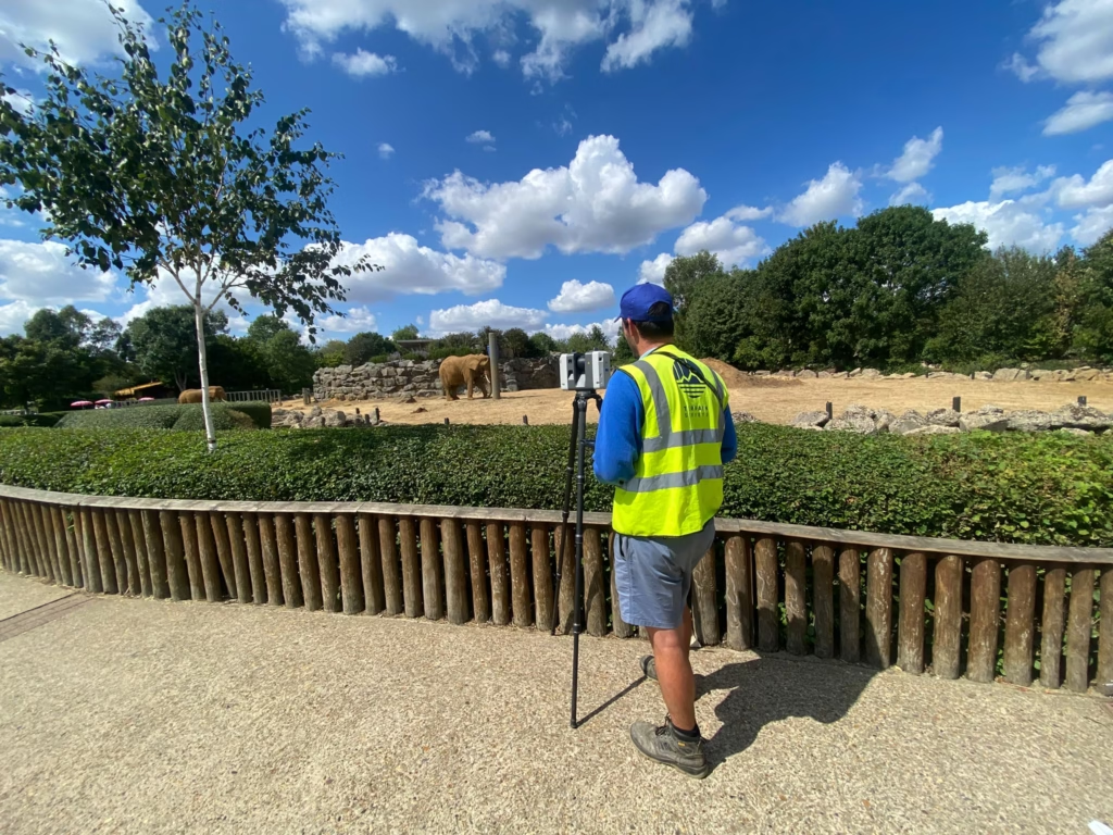
Terrain Surveys were commissioned by the project architect to carry out a Topographical Survey of several animal enclosures within the zoo. Due to the unique setting, particular care had to be taken to ensure the safety and wellbeing of both animals and surveyors, as well as to minimise disruption to daily zoo operations.
- Lion Enclosure: Surveying such an environment comes with obvious challenges. To prevent any disturbance or risk, our team utilised the Leica RTC360 laser scanner, allowing us to capture highly detailed data remotely, without needing to enter the enclosure.
- Gelada Monkey Enclosure: This survey was conducted during standard hours while the monkeys roamed freely. Zoo staff assisted throughout, ensuring the animals were safely kept at a distance from our surveyors and equipment.
- Other Enclosures: Similar considerations applied across the site, with our team working methodically to complete the work with minimal impact on the animals.
The survey was completed over 2 days, with our team making the most of this unusual working environment – even taking time to observe some of the zoo’s other residents while scans were processed. For many of our surveyors, it was a memorable and enjoyable day on site, and certainly something out of the ordinary compared to typical urban or commercial projects.
Results
The topographical survey produced a comprehensive dataset and set of drawings detailing the terrain, boundaries, features, and infrastructure of the surveyed enclosures. Standard deliverables included:
- 2D topographical drawings (showing levels, contours, and key features)
- 3D point cloud data captured via laser scanning
- Digital CAD files for direct integration into the architect’s design workflow
This output equips the architects with the accurate spatial information they need to progress design and planning works aligned to Colchester Zoo’s 2023 master plan. Whether designing expanded habitats, introducing new structures, or upgrading visitor facilities, precise survey data is essential to ensure that proposals are both technically feasible and sympathetic to the existing site.
For Terrain Surveys, this was an unusual and rewarding commission – bringing our expertise to a project that balances visitor experience, animal welfare, and long-term conservation.