Whether you’re breaking ground on a multi-million-pound development, designing a new public space, or simply planning your dream home extension, every successful project starts with one thing: understanding the ground beneath your feet.
And that’s precisely where a topographical survey comes in.
Think of it as the master plan for your plan – the foundational document that transforms an idea into a buildable reality.
In this article, we’ll demystify the ‘topo’ survey. We’ll explain what it is, what we do on-site, and most importantly, why it’s one of the most critical investments you can make for your project’s success.
As a company that has been delivering high-quality, accurate measured surveys since 2004, we’ve seen firsthand how a proper survey can save clients time, money, and countless headaches.
We’ve worked with everyone from homeowners planning modest extensions to developers orchestrating complex commercial schemes.
And if there’s one thing we’ve learnt, it’s this:
The projects that start with a comprehensive topographical survey are the ones that tend to finish on time, on budget, and without nasty surprises.
What Exactly is a Topographical Survey?
Let’s cut through the jargon.
A topographical survey is a detailed, accurate map of a specific piece of land. It identifies and plots all the natural and man-made features within that area, creating a precise snapshot of your site as it exists today.
But it’s more than just a pretty drawing.
It’s a technical document that captures the three-dimensional characteristics of your land – every rise, fall, and feature that could impact your project.
What We Actually Map
When our surveyors arrive on your site, they’re looking at everything. And we mean everything.
Natural Features:
- Trees (including species identification, height, and canopy spread)
- Streams, ponds, and water features
- Ground levels and contours
- Changes in elevation and slopes
- Hedgerows and vegetation boundaries
- Rock outcrops and natural formations
Man-made Features:
- Existing buildings and structures
- Boundary walls and fences
- Roads, pathways, and paved areas
- Manholes and inspection chambers
- Utility covers and service markers
- Street furniture and signage
- Drainage gullies and channels
- Overhead cables and their heights
Every single feature is precisely located and recorded. Because in our experience, it’s often the detail you didn’t think was important that becomes crucial later.
The Technology Behind Modern Surveying
Gone are the days of surveyors squinting through theodolites and scribbling in notebooks.
Today’s topographical surveying is a high-tech operation.
At Terrain Surveys, we’ve invested heavily in the latest equipment to ensure accuracy and efficiency.
Our toolkit includes:
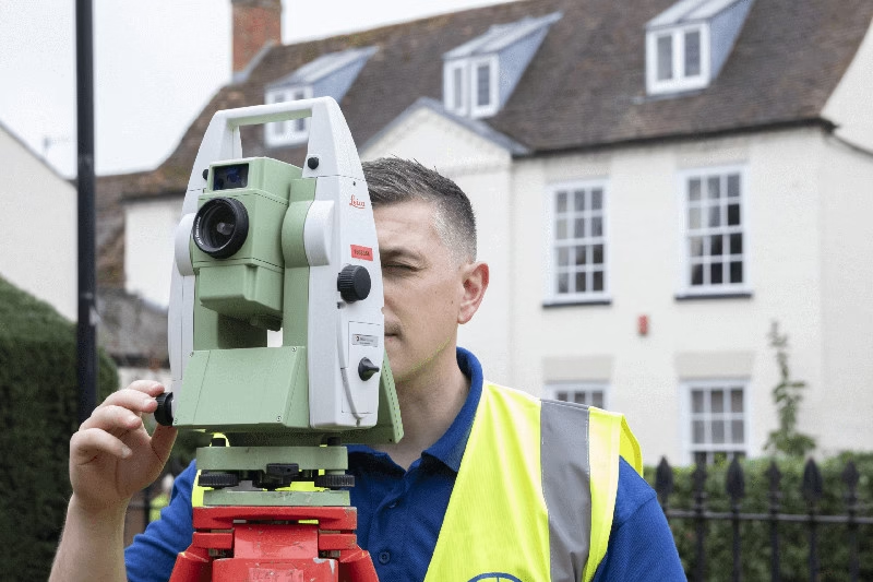
Robotic Total Stations – These clever pieces of kit can track a single surveyor as they move around the site, automatically recording thousands of data points with millimetre accuracy. They’re particularly brilliant for capturing complex sites with multiple level changes.
GNSS Receivers – Using satellite positioning, our GNSS systems tie your survey directly to the Ordnance Survey national grid. This means your architect’s plans will align perfectly with planning applications and utility records.
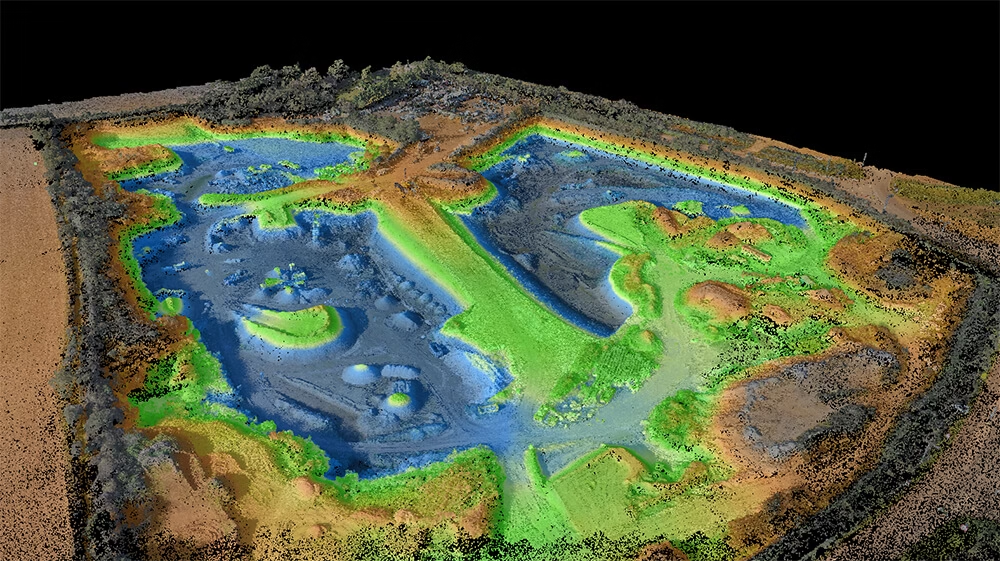
3D Laser Scanners – For particularly complex or detailed sites, we deploy laser scanning technology. These scanners capture millions of points per second, creating what we call a ‘point cloud’ – essentially a three-dimensional photograph of your site.
Drones – For certain sites we deploy drones to survey from the air. They can rapidly capture ground information across large sites, and grab details of tall structures such as trees and roofs.
This technology isn’t just about showing off our kit.
It’s about delivering surveys that are accurate, comprehensive, and completed quickly without disrupting your site.
What You Actually Receive
After we’ve captured all that data, what do you get?
The final product is a highly detailed digital drawing that becomes the foundation for your entire project. We deliver surveys in whatever format your team needs:
- 2D CAD drawings (.dwg) – The industry standard for architects and engineers
- 3D models (Revit) – Perfect for BIM workflows and visualisation using software like Autodesk Revit
- PDFs – For easy viewing and sharing with stakeholders
- Paper plots – When you need physical copies for site meetings
Crucially, all our surveys are tied to the Ordnance Survey (OS) national grid and datum. This isn’t just a nice-to-have – it’s essential for UK projects. It ensures your plans align with local authority mapping, utility records, and neighbouring properties.
Your survey becomes a living document that multiple professionals can work from simultaneously, confident they’re all singing from the same hymn sheet.
Why You Might Need One
Now, here’s where it gets interesting.
The value of a topographical survey changes depending on who you are and what you’re trying to achieve. So let’s break it down by audience.
For Architects & Engineers
As an architect or engineer, a topo survey is your design canvas. It provides the critical context you need to ensure your vision can be realised.
Without it, you’re essentially designing in the dark.
Think about it. How can you position a building to maximise natural light if you don’t know the exact orientation and surrounding features? How can you design proper drainage without understanding the existing ground levels and flow patterns?
A comprehensive topographical survey reveals the constraints and opportunities that shape every design decision. It identifies that mature oak tree that needs protecting, the steep slope that’ll require retaining walls, or the perfect natural depression for sustainable drainage.
It’s essential for:
- Planning site access and construction logistics
- Calculating accurate gradients for disabled access compliance
- Ensuring your design meets planning regulations
- Identifying existing services that could impact foundation design
- Understanding sight lines and visual impact
We’ve worked with countless architects who’ve told us the same thing: a detailed topo survey at the start saves weeks of revisions later.
For Property Developers
For developers, a topographical survey isn’t just useful – it’s a tool for risk management and maximising value.
It’s the cornerstone of a successful feasibility study.
Here’s the reality: most local authorities won’t even look at your planning application without a proper topographical survey.
It’s a non-negotiable requirement that shows you’ve done your homework and understand the site you’re proposing to develop, often submitted via the UK’s Planning Portal.
But beyond the planning process, a topo survey delivers real commercial value:
Accurate cut-and-fill calculations – We’ve seen developers save tens of thousands on earthworks simply by having precise level data from the start. You’ll know exactly how much soil needs moving, where it’s coming from, and where it’s going.
Optimised site layout – Understanding your site’s topography helps maximise development potential. That awkward slope might actually allow for an extra storey without breaching height restrictions. The natural levels might enable split-level designs that increase your sellable floor area.
Infrastructure planning – Knowing where existing services run prevents costly diversions. Understanding natural drainage patterns helps design efficient surface water management systems.
Reduced risk – Every unknown is a potential cost overrun waiting to happen. A comprehensive survey eliminates the unknowns.
For Facilities Managers
If you’re managing a large estate – whether it’s a business park, hospital, university campus, or industrial complex – a current topographical survey is an invaluable asset management tool.
Think of it as the definitive record of your site.
When you need to plan maintenance, upgrade infrastructure, or respond to emergencies, you need accurate, up-to-date information.
A topographical survey provides exactly that.
It’s particularly valuable for:
- Planning maintenance schedules for grounds and infrastructure
- Upgrading drainage systems or installing new cabling routes
- Managing health and safety by identifying potential hazards
- Coordinating with contractors who need accurate site information
- Planning new developments or modifications to existing facilities
- Creating emergency response plans
We work with facilities managers who update their surveys every few years, treating them as living documents that evolve with their estates. It’s a small investment that pays dividends in operational efficiency.
For Homeowners
Planning an extension or a major garden redesign?
A topographical survey can be the difference between a smooth project and a costly nightmare.
Your architect will almost certainly need one to design your extension accurately. They need to know the exact relationship between your house and garden levels, where the boundaries are, and what obstacles might affect the build.
But here’s what many homeowners don’t realise: councils often require a topographical survey as part of your planning permission application. Without it, your application might be refused or delayed whilst you scramble to get one done.
A proper survey reveals:
- Level changes you might not have noticed (crucial for extension floor levels)
- The exact position of boundaries (avoiding neighbour disputes)
- Trees that might be protected or affect foundations
- Existing drainage that needs protecting or diverting
- The relationship between your property and neighbouring buildings
We’ve seen too many homeowners try to save money by skipping the survey, only to face expensive problems later. That “minor” slope becomes a major retaining wall. That drain they didn’t know about gets damaged during excavation.
Get the survey done properly from the start. Your future self will thank you.
Our Process: How We Work With You

At Terrain Surveys, we’ve refined our process over nearly two decades to make getting a topographical survey as straightforward as possible.
Here’s exactly how it works.
Step 1: Initial Consultation & Free Quote
It all starts with a conversation.
We take the time to understand your project’s specific requirements. Every site is different, and every client has unique needs. Maybe you need particular attention paid to tree positions for an arboricultural report. Perhaps you require specific detail around a listed building. Or you might need the survey tied into existing architect’s drawings.
Whatever your requirements, we’ll discuss them thoroughly.
We offer free, no-obligation quotes and professional advice to ensure you get the right survey for your needs. There’s no hard sell, no pressure. Just honest guidance from professionals who’ve been doing this since 2004.
Often, we can provide a quote the same day. For more complex sites, we might arrange a site visit to ensure our quote is comprehensive and accurate.
Step 2: The On-Site Survey
Once you’re ready to proceed, we’ll schedule the survey at a time that suits you.
Our team of friendly, professional surveyors will visit your site. All our site staff hold valid CSCS cards and are fully trained in health and safety. They’ll arrive in branded vehicles, wearing branded clothing, and carrying identification.
They know what they’re doing, and they do it efficiently.
Using our state-of-the-art equipment, they’ll methodically capture all the necessary data. For a typical residential plot, this might take half a day. For a large commercial site, it could be several days. Either way, our surveyors work non-intrusively, causing minimal disruption to your site or operations.
If you’re on-site during the survey, our team is always happy to explain what they’re doing and answer any questions. We find clients are often fascinated by the technology and process.
Step 3: Data Processing & Quality Assurance
Back in the office, our team processes the raw data.
This is where our commitment to quality, demonstrated by our ISO 9001 accreditation, really shines through.
The thousands of data points captured on-site are transformed into clear, accurate drawings. Every level is checked. Every feature is verified. Every dimension is confirmed.
We operate a rigorous quality assurance process. A senior surveyor reviews every drawing before it leaves our office. Because we know that even a small error can cause big problems down the line.
If we spot anything unusual or potentially problematic – like evidence of Japanese knotweed or signs of subsidence – we’ll flag it immediately. We see ourselves as partners in your project’s success, not just data providers.
Step 4: Delivering Your Survey
We pride ourselves on meeting our clients’ strict deadlines.
You’ll receive your final, accurate survey drawings in your required digital format, ready for you or your design team to start work. We’ll ensure the files are compatible with your software and include all the layers and information you need.
But our service doesn’t end there.
If your architect has questions about the survey, we’re happy to clarify. If you need additional formats or paper copies, we’ll sort them out. If you require variations or additional detail in certain areas, we can often extract this from our original data without needing another site visit.
We’re here to support your project from start to finish.
Start Your Project on Solid Ground
A topographical survey isn’t an expense; it’s an investment in certainty.
It provides the essential foundation for any project, mitigating risks and preventing costly errors down the line. Whether you’re an architect crafting the perfect design, a developer maximising site potential, a facilities manager maintaining a complex estate, or a homeowner realising your dream extension, it all starts with understanding your site.
We’ve seen projects derailed by unexpected level changes. We’ve watched budgets blown by unforeseen drainage issues. We’ve witnessed neighbour disputes that could have been avoided with proper boundary mapping.
But we’ve also seen the opposite.
Projects that flow smoothly from conception to completion. Designs that work perfectly with the natural topography. Developments that maximise value whilst minimising earthworks costs. Extensions that slot seamlessly into existing gardens.
The difference? They all started with a comprehensive topographical survey.
Ready to Start Your Project Right?
If you’re ready to start your project on solid ground, our team is here to help.
We’re not just surveyors. We’re partners in your project’s success. We’ll take the time to understand your needs, deliver the survey you require, and support you throughout your development journey.
Don’t leave your project’s foundation to chance.
Contact us today for a free, no-obligation quote and expert advice.
Our experienced team is available across the UK, ready to discuss your project and provide the professional guidance you need.
Whether you’re planning next year’s major development or need a survey completed urgently, we’re here to help. Let’s talk about your project and how we can provide the accurate, reliable topographical survey you need.
Because every successful project starts with understanding the ground beneath your feet.
And we’re here to help you understand yours.