Imagine you’re standing on a plot of land. To the naked eye, it might look relatively flat. But is it really? Where will rainwater naturally flow? Are there subtle undulations that could complicate a foundation?
Before a single shovel hits the ground on any project – from a garden extension to a major housing development – these are the critical questions that need answers.
And that’s precisely where a topographic survey comes in.
Here at Terrain Surveys, we’ve been providing the data for projects across the UK since 2004. We’ve seen first-hand how a detailed topographic map is the foundational blueprint for success, preventing costly mistakes and ensuring a smooth process from start to finish.
In this article, I’ll explain what a topographic map is, what it’s used for, and why it’s one of the most important investments you can make for your project.

What Exactly is a Topographic Map?
Put simply, a topographic map is a detailed, scaled drawing of a piece of land that shows its three-dimensional nature on a two-dimensional surface.
Think of it as your land’s unique fingerprint.
Unlike a standard map that might show you where roads and buildings are, a topographic map reveals the actual shape and character of the terrain. It’s the difference between knowing there’s a hill on your property and understanding exactly how steep it is, where it peaks, and how water will flow down its slopes.

The Key Features You’ll Find
- Contour lines are the backbone of any topographic map. These are lines that connect points of equal elevation, essentially showing you the ‘shape’ and steepness of the land. When contour lines are close together, you’re looking at a steep slope. When they’re spread apart, the ground is relatively flat.
- Spot levels give you specific height measurements at crucial points across the site. These are particularly important for engineers calculating drainage gradients or architects determining floor levels.
- Natural features are meticulously recorded too. We document trees (often including their species, height, and canopy spread), streams, ponds, and significant vegetation. This isn’t just about pretty pictures – it’s usable data for planning applications and environmental assessments.
- Man-made features complete the picture. Buildings, roads, walls, fences, manholes, street furniture, and other services visible on the surface are all captured. Every detail matters when you’re planning a development or managing an estate.
What sets our surveys apart from standard Ordnance Survey data is the level of detail. Whilst OS maps are brilliant for general reference, they simply don’t provide the precision needed for construction and development projects. Our surveys capture the specific, current state of your site with millimetre accuracy.
How is a Topographic Survey Carried Out?
So, how do we capture all this information? It’s a blend of cutting-edge technology and expert skill.
Our surveyors will visit your site equipped with high-precision instruments. The workhorses are often a Total Station – a device that measures angles and distances with incredible accuracy – and GPS equipment that ties the survey into the national grid.
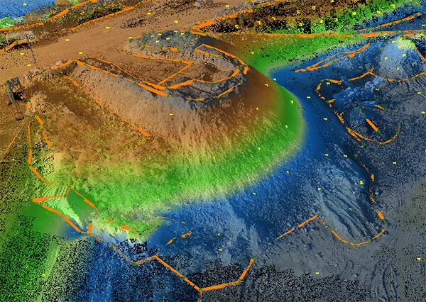
For complex sites or when even greater detail is needed, we use 3D Laser Scanners. These instruments capture millions of data points in minutes, creating a dense ‘point cloud’ that forms a highly detailed 3D model of the site.
Back in the office, this raw data is processed by our experienced technicians to produce the final, easy-to-read 2D or 3D drawings that become your project’s blueprint.

The Core Uses: Who Needs a Topographic Survey and Why?
For Architects & Property Developers
If you’re an architect or developer, a topographic survey isn’t just useful – it’s essential.
Feasibility and site planning start here. Before you can determine if a design is viable, you need to understand the canvas you’re working with. The survey helps determine the best placement for buildings, access roads, and amenities. It reveals opportunities you might not have spotted and constraints you need to work around.
Planning applications in the UK almost always require a detailed topographic survey. Local authorities need to see how your proposed development will sit within the existing landscape, its visual impact, and how you’re managing surface water.
Speaking of drainage, your drainage strategy depends entirely on accurate topographic data.
With an increasing focus on Sustainable Drainage Systems (SuDS), you need to know exactly how water naturally flows across your site to design effective, compliant solutions.
Here’s a fact that might surprise you: inaccurate ground information is one of the leading causes of initial design rework. When the real ground conditions don’t match the assumptions, entire designs need revisiting. That means project delays and budget overruns.
For Engineers (Civil & Structural)
Engineers, you know better than most that precision isn’t optional – it’s fundamental.
Earthworks calculations rely entirely on accurate topographic data. Calculating ‘cut and fill’ volumes – the amount of soil to be removed (cut) or added (fill) to level a site for construction – requires precise measurements. Even small errors can translate into thousands of pounds in unexpected costs for soil removal or delivery.
Infrastructure design demands absolute accuracy. Whether you’re designing roads, railways, or pipelines, gradients must be correct and workable. A road that’s too steep or a pipeline that doesn’t flow properly aren’t just inconveniences; they’re project killers.
Flood risk assessments have become increasingly important in UK planning. Your topographic survey provides the raw data needed to model potential flood risks and demonstrate your mitigation strategies to the Environment Agency and local planners.
For Facilities & Estate Managers
Managing a large site? Then you already know that accurate data is the backbone of effective estate management.
Asset management becomes infinitely easier with a comprehensive topographic survey. For large sites like university campuses, hospitals, or business parks, it provides an accurate, single source of truth for your entire estate.
Maintenance and future planning depend on this data. Need to install new utilities or plan a new pathway? Your topographic map if combined with subterranean survey data helps you avoid costly mistakes like accidentally cutting through services or creating drainage problems.
Health and safety considerations are crucial too. A proper survey identifies potential hazards like steep slopes, ditches, or uneven ground. This is vital for managing public liability and keeping people safe on your site.
For Homeowners
You might think topographic surveys are just for big developments, but that’s not true at all.
Extensions and landscaping projects benefit enormously from proper surveying. It ensures your extension’s foundation is correctly designed and prevents your new patio from causing a drainage nightmare for you or your neighbours.
Planning permission often requires a topographic survey, even for domestic projects. If you’re planning an extension or significant garden work, the council will likely ask for one to see how your changes affect the site.
Beyond that, there’s peace of mind. A survey provides a clear understanding of your property’s boundaries and features, which is invaluable for resolving disputes or simply knowing exactly what you own.
Why Accuracy is Everything (The Cost of Getting it Wrong)
A map is only as good as the data behind it.
And when it comes to topographic surveys, “good enough” simply isn’t good enough. The financial, legal, and logistical risks of inaccuracy are just too high. Budget overruns, disputes with neighbours, and construction delays can all stem from a poor-quality survey.
The Terrain Surveys Commitment to Excellence
This is why we never compromise on accuracy.
We invest heavily in the latest surveying technology, but technology is only part of the equation.
Our surveyors are highly trained professionals who understand that their work forms the foundation of your project.
All our team members carry CSCS cards for site work, ensuring they meet the highest safety standards. Our commitment to quality is backed by our ISO 9001:2015 accreditation and our membership of leading industry bodies like The Survey Association (TSA) and the Chartered Institution of Civil Engineering Surveyors (CICES).
These aren’t just badges. They represent our ongoing commitment to maintaining the highest professional standards in everything we do.
Your First Step to a Successful Project
A topographic survey isn’t a cost – it’s an investment that saves time, money, and stress.
It’s the essential foundation for any successful project.
Whether you’re an architect shaping a new skyline, an engineer building vital infrastructure, or a homeowner creating your dream space, understanding the ground beneath your feet is the first and most crucial step.
The clients who invest in proper surveys at the beginning consistently deliver their projects on time and on budget. You can see examples of the diverse projects we’ve supported in our case studies.
If you’re ready to start your project on solid ground, our team is here to help. We provide free, no-obligation quotes and are always happy to offer professional advice to ensure you get the data you need.


