It’s one of the most common questions we receive at Terrain Surveys. And I completely understand why. Whether you’re an architect preparing a tender, a developer working out project feasibility, or a homeowner planning your dream extension, you need to know what you’re in for financially.
Here’s the thing: asking for a fixed price for a topographic survey is a bit like asking “how long is a piece of string?” or “how much does a building project cost?” The honest answer is: it depends entirely on your specific requirements.
In this article, I want to demystify the costs for you. Instead of giving you a meaningless average price that won’t apply to your project, I’ll walk you through the key factors that we, as surveyors, use to prepare a quote. This will empower you to understand what you’re paying for and ensure you get the right survey for your project.
A Quick Refresher: What is a Topographic Survey?

Before we dive into costs, let’s quickly clarify what we’re talking about.
A topographic survey is essentially a detailed digital map of a piece of land. It shows the ‘lie of the land’ including natural features like trees and slopes, man-made features like buildings and walls, boundaries, and crucially, the ground levels (heights) across the site.
Think of it as the essential foundation for any successful design, planning application, or construction project. Without it, you’re building blind.
The 7 Key Factors That Determine the Cost of Your Survey
Let me break down exactly what goes into our pricing calculations when we prepare your quote.
1. The Size of the Area
This is the most obvious factor, but it’s worth stating clearly.
A larger site takes more time to survey than a smaller one. Simple as that.
Surveying a typical residential garden for a home extension might take our team less than half a day.
Surveying a multi-acre commercial estate could take several days or even weeks. The equipment might be the same, the expertise might be the same, but the time on site – and therefore the cost – is vastly different.
2. The Complexity of the Site
Not all sites are created equal.
A flat, open, rectangular field? That’s straightforward. We can set up our equipment with clear sight lines and work efficiently.
But a site that’s heavily sloped, has irregular boundaries, or features multiple buildings, retaining walls, and dramatic level changes? That requires significantly more time and cost.
We might need to set up our equipment multiple times to capture all the angles. We might need to take hundreds more measurements to accurately map complex features.
I’ve surveyed sites where a single boundary wall has taken longer to accurately capture than an entire simple garden.
3. The Level of Detail Required
This is a critical cost driver that many people don’t initially consider.
Basic survey requirements might include:
- Building footprints
- Boundary lines
- Key ground levels
- Major features like driveways
Detailed survey requirements could include:
- Every tree (with species, height, and canopy spread)
- Every manhole cover (with cover levels and invert levels)
- Every lamp post, bollard, and street furniture item
- Every kerb line and change in surface material
- Ridge and eaves heights of all buildings
- Window and door positions
- Drainage runs and service positions
The more data points we need to capture, the longer it takes. A survey for a simple permitted development application will cost less than one for a complex architectural design that needs every minute detail.

4. Vegetation
Here’s something that might surprise you: vegetation can significantly impact survey costs.
A site covered in dense trees, bushes, and undergrowth is much harder to survey than an open lawn. Our surveyors have to navigate through the vegetation, often taking more measurements to “see” through gaps in the foliage. In extreme cases, we might need to use different equipment or techniques to ensure accuracy.
I remember one project where we had to survey a Victorian walled garden that hadn’t been maintained for decades. What looked like a half-day job on paper turned into two days of careful work, navigating through brambles and ensuring we captured accurate ground levels beneath the overgrowth.
5. Accessibility & Location

Our teams operate UK-wide from our offices in Hertfordshire, the Midlands, Bristol and Sussex. But travel time and site accessibility are genuine factors in cost.
A remote site in the Scottish Highlands will have different logistical costs than one in central Birmingham. Similarly, a site with restricted access – perhaps we need to carry equipment through your house to reach a landlocked garden – takes more time than one where we can park adjacent and walk straight on.
Some sites require special access permissions, working at height qualifications, or coordination with multiple parties. All of this impacts the final cost.
6. The Required Deliverables
What do you actually need at the end of the survey?
Most clients require 2D CAD drawings in formats like .dwg or .dxf files that their architects or engineers can work with directly. This is a standard deliverable.
But some projects benefit from:
- 3D models for visualisation
- Point cloud data for complex analysis
- Topographic contour maps
- Multiple drawing scales or formats
- Paper copies in addition to digital files
Each additional deliverable requires more processing time after the site survey, which affects the overall cost.
7. Urgency
We always work to meet our clients’ deadlines. That’s part of our commitment to service.
But if your project requires an exceptionally fast turnaround – perhaps you need results within 48 hours, or require weekend working to avoid disrupting business operations – this may be reflected in the cost. Rush jobs often mean reorganising our schedule, overtime for processing, or bringing in additional team members.
Why the Cheapest Quote is a Risk You Can’t Afford
I need to be frank with you about something.
An accurate topographic survey is not an expense. It’s an investment in the success of your project.
We regularly see the consequences of clients who’ve tried to save a few hundred pounds by going with the cheapest quote.
The results can be catastrophic:
- Inaccurate data leads to flawed architectural designs. I’ve seen extensions designed based on incorrect levels, meaning the planned structure wouldn’t actually fit the site.
- Planning applications get rejected. Local authorities are increasingly strict about accuracy. If your survey doesn’t match reality, your application could be refused, costing you months of delays.
- Construction errors that cost thousands to fix. The worst case we encountered? A developer who used a cheap survey that got the levels wrong. The drainage was designed to flow uphill. The mistake wasn’t discovered until groundworks had begun. The rectification costs? Over £30,000.
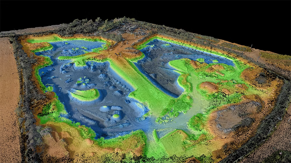
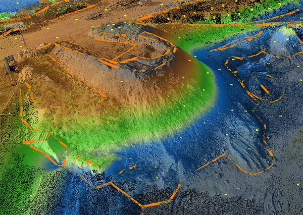
At Terrain Surveys, our commitment to quality isn’t just marketing speak. It’s demonstrated by our ISO 9001 accreditation and our membership of The Survey Association (TSA). We invest heavily in the latest technology, including high-definition laser scanners that ensure millimetre-level accuracy. We operate 3D scanners that can capture real-world objects in complete detail, and we not only check everything via ground stations, but also from the air using drones.
Our surveyors are all highly trained and hold CSCS cards. We’re an accredited member of schemes like Constructionline Gold and Acclaim, which are part of the Safety Schemes in Procurement (SSIP) forum. These aren’t just badges – they’re your guarantee of professional standards and accountability.
When you choose a professional surveying company, you’re not just buying data points on a drawing. You’re buying the peace of mind that comes with a highly structured and industry approved process.
So, What Does a Topographic Survey Actually Cost?
After all these factors, you’re probably still wondering about actual numbers.
The truth is, every survey is unique. But to give you some context:
A simple residential garden survey for a home extension might start from a few hundred pounds. A complex commercial site requiring detailed analysis could run into several thousand.
But these figures are meaningless without understanding your specific requirements.
What I can tell you is this: the cost of getting it right the first time is always less than the cost of fixing mistakes later.
How We Calculate Your Quote
When you contact us for a quote, here’s what happens:
We listen first. We’ll ask about your project, your timescales, and most importantly, what you’re planning to do with the survey. This helps us recommend the right level of detail.
We assess your site. Using aerial imagery and our local knowledge, we’ll evaluate the complexity and accessibility of your location.
We provide a detailed proposal. Our quotes aren’t just a number on a page. We’ll explain exactly what’s included, what format you’ll receive the data in, and our timescales for delivery.
We offer advice. If we think you’re over-specifying (paying for detail you don’t need) or under-specifying (risking problems later), we’ll tell you. Our integrity means we’d rather lose a job than see you make an expensive mistake.
The Hidden Costs of Getting It Wrong
Let me share a real example from last year.
A homeowner came to us after their planning application was rejected. They’d used a “budget” surveyor who’d missed several key features and got the boundary positions wrong. The architect had designed a beautiful extension based on this flawed data.
The consequences?
- Planning application rejected (£500 lost)
- Architect’s designs needed complete revision (£2,000 in additional fees)
- Six-month delay to the project
- When construction finally started, unexpected level differences meant additional groundworks (£5,000 extra)
The “saving” from using a cheap survey? About £400. The total additional cost? Over £7,500, plus six months of delays.
What Makes a Professional Survey Worth the Investment?
When you work with Terrain Surveys, you’re not just paying for someone to measure your land.
You’re investing in:
Technology that delivers accuracy. Our laser scanners can capture millions of data points with millimetre precision. This isn’t overkill – it’s the difference between a design that works and one that doesn’t.
Experience that spots problems before they happen. With over 20 years in the industry, our surveyors know what to look for. We’ll flag potential issues that could affect your project, from boundary discrepancies to hidden level changes.
Professional indemnity insurance that protects you. In the unlikely event something goes wrong, you’re covered. Can your budget surveyor say the same?
A team that understands deadlines. We know that delays cost money. That’s why we commit to delivery dates and stick to them.

Making the Right Choice for Your Project
Choosing a surveying company shouldn’t be about finding the cheapest quote. It should be about finding the right partner for your project.
Ask yourself:
- Can I afford for this to go wrong?
- Will delays cost me more than the survey itself?
- Do I need professional accountability and insurance backing?
- Is my project important enough to get right the first time round?
If you answered yes to any of these, then you need a professional survey from an accredited company.
Ready to Get Started?
As you can see, the cost of a topographic survey is tailored to the unique demands of your site. It’s a precise process where the price is a direct reflection of the work required to protect your investment.
By choosing a professional, accredited surveying company, you’re buying peace of mind and setting your project on the path to success from day one.
We provide a free, no-obligation quotation for every project.
Our team will take the time to understand your needs and provide a clear, detailed fee proposal outlining exactly what’s included. There are no hidden costs, no surprise extras, and no pressure to proceed.
For free professional advice and a bespoke quote for your project, please get in touch with our team today.
Whether you’re planning a small extension or a major development, we’re here to help ensure your project starts on solid ground – literally.