I’ve been a surveyor for 25 years, during which time I’ve personally carried out hundreds of surveys using a total station. In that time, the accuracy and efficiency gains have been dramatic – what once required two people and a full day in the field can now be completed by one surveyor in a few hours.
Today, we have drones, 3D laser scanners, and GPS technology that would have seemed like science fiction not too long ago.
But here is the thing.
Despite all of that, there is one piece of kit that remains the absolute backbone of professional surveying.
As surveying technology has evolved at a pace that would have been unimaginable at the start of my career, tools such as mobile mapping, drones, and terrestrial laser scanning have not only become mainstream but are now an expected part of every surveyor’s toolkit. Yet one thing remains true: no matter how advanced or automated your equipment is, it cannot compensate for weak survey control. This is where the total station is truly indispensable.
A total station is essential for establishing a solid, robust control network through precise angular and distance measurements. That control network is the starting point for every other survey measurement and observation on site. Without it, your survey data will be questionable at best.
If you procure surveys of any kind, there is one simple but powerful question you should always ask your provider: what is your approach to survey control, and how will it be established? A credible surveyor will be glad to walk you through their methodology and provide a survey control report on request. Someone who cannot answer the question confidently is not just a risk – they are a liability for your project.
This is, in some ways, a downside of rapid progress in surveying technology: equipment is now so user-friendly that almost anyone can operate it. Make sure you are engaging a qualified surveyor – not just a button-pusher. The technology does not make the surveyor. The surveyor makes the technology useful.
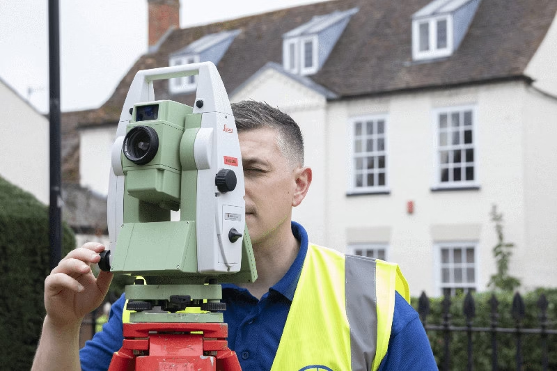
You’ve probably seen it on site – a yellow or green instrument mounted on a tripod, with a surveyor peering into it and occasionally calling out numbers.

That is a total station.
And if you’ve ever stood there wondering what on earth that thing is actually doing, this article is for you.
Whether you’re a homeowner planning an extension, an architect working up initial designs, or a developer managing a large-scale commercial build, understanding what a total station does will help you appreciate why accurate survey data is the single most important investment you can make before work begins.
What Exactly is a Total Station?
Think of it this way: a total station is essentially a highly advanced digital tape measure and protractor, combined into one incredibly precise instrument.
But that description doesn’t quite do it justice.
In technical terms, a total station is an optical surveying instrument that combines three key technologies. As professionals adhering to the standards set by the Royal Institution of Chartered Surveyors (RICS), we rely on all three components daily.
The Electronic Theodolite
This is the angle-measuring component. It calculates both horizontal and vertical angles to an extraordinary degree of precision. We are talking fractions of a second of arc, equivalent to less than 0.0003 degrees.
The EDM (Electronic Distance Measurement)
This is the distance-measuring component. It fires a laser beam to a target point and measures exactly how far away it is, accurate to within 1-2 millimetres.
In standard mode, the laser bounces off a reflective prism held by a second surveyor. In reflectorless mode, it bounces directly off a surface (a wall, the ground, or even a building facade) without anyone needing to hold a target. In reflectorless mode, a modern total station can typically measure accurately up to 300-500 metres depending on surface conditions; with a reflective prism, that range extends to several kilometres.
The Onboard Microprocessor
This is where the magic happens. The instrument’s built-in processor takes the angle and distance readings and instantly calculates the precise X, Y, and Z coordinates of that point in three-dimensional space.
Every measurement is recorded digitally in real time. No clipboards. No manual calculations. No human error creeping into the numbers.
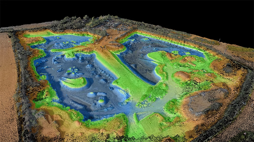
On a typical medium-sized commercial development, we capture approximately millions of measured points in a single day’s fieldwork. With manual methods, the same site would have taken three days and required a team of two.

Once we’re back in the office, that data downloads directly into our CAD (Computer-Aided Design) or Building Information Modelling (BIM) software. From there, your accurate 2D plans or 3D models are well on their way.
That combination of long range and millimetre accuracy is what makes a total station so indispensable on a professional survey.
How We Use a Total Station and Why It Matters for Your Project
A total station isn’t a one-trick instrument. The way we use it varies significantly depending on what your project actually needs.
Here is how it applies across the different types of work we carry out at Terrain Surveys.
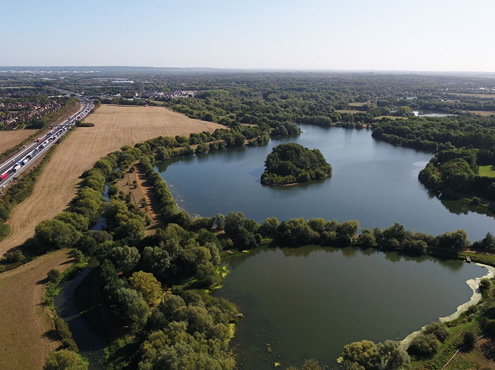
Topographical Surveys: For Developers and Architects
If you’re planning a new build or a significant development, the first thing you need is an accurate picture of the land itself.
We use the total station to map out the exact contours, boundaries, and physical features of a site. This includes trees, drainage channels, changes in level, existing structures, and access points – basically everything that will influence how your project is designed and delivered.
Our standard approach involves establishing a closed-loop traverse through total station observations and carrying out an independent check on the vertical (‘Z’) values of the control station coordinates to ensure they are correct and accurate.

The Z value is generally the weakest coordinate in a control network and the cause of the majority of issues encountered on site – which is why at Terrain Surveys we always verify our level data with an independent check. Before we begin any data collection, we establish control stations using total station observations tied into the Ordnance Survey National Grid with static GNSS observations, with control station levels independently verified using an optical level and staff. This control framework is what underpins every measurement that follows.
That data becomes the foundation of your topographical survey drawing.
When your architect or engineer sits down to start designing, they are working from reality, not assumptions.
A design based on inaccurate ground data can lead to planning complications, structural miscalculations, and expensive redesigns further down the line. Getting it right at the start is always cheaper than fixing it later.
Measured Building Surveys: For Homeowners and Architects
Planning a home extension? Refurbishing a commercial property? Converting a listed building?
Your architect needs to know the exact dimensions of what already exists before they can design what comes next.

A recent project illustrates exactly why this matters. We carried out a measured building survey of a Grade II listed farmhouse where the as-built dimensions differed from the original drawings by 200mm in several critical locations. Had the architect proceeded without an accurate survey, the extension design would have run into significant delays and additional costs – several components were being manufactured off site to precise measurements. The survey took eight hours on site and delivered detailed 1:50 scale floor plans, sections, external elevations, and topographical and PAS128 utility drawings.
We use the total station – often alongside 3D laser scanning technology – to capture every measurement of the existing structure. Floor plans, elevations, ceiling heights, wall thicknesses, and structural quirks. All of it recorded to millimetre accuracy.
The result is a set of measured building survey drawings that give your architect a precise, reliable starting point. No guesswork. No “near enough.” Just accurate data.
Setting Out: For Engineers and Construction Teams
Here is one that often surprises people: a total station doesn’t just capture data. It can work in reverse.
Once your design has been signed off, we upload the design coordinates directly into the total station. We then use it on site to physically mark out exactly where things need to go, including foundations, columns, walls, steelwork, drainage runs.
This process is called setting out, and it is critical to construction accuracy. If a foundation is laid even slightly out of position, the knock-on effects can be significant. Setting out ensures that what gets built matches what was designed, to the millimetre.
On one recent project, the design required positioning steelwork to within 5mm of tolerance. The total station allowed us to achieve this in a single day’s fieldwork, giving the contractor immediate confidence to proceed.
Monitoring Surveys: For Engineers and Facilities Managers
Some structures need to be watched carefully. Think the Leaning Tower of Pisa as a famous example.
Retaining walls, bridges, historic buildings, and large construction projects near existing structures can all be subject to movement over time. Sometimes this movement is noticeable. Often it is not.
We use highly precise total stations to monitor fixed reference points on a structure at regular intervals. By comparing measurements taken weeks or months apart, we can detect tiny movement down to a single millimetre. Monitoring surveys are one of the most effective early-warning systems available, and an important part of complying with Health and Safety Executive (HSE) guidelines on structural monitoring.
Catching subtle movement early can prevent a minor issue from becoming a serious and costly structural problem.
Why Accurate Survey Data is the Best Investment You’ll Make
It is easy to view a survey as just another box to tick before the real work starts. It isn’t.

The data we collect with a total station is the foundation everything else is built on – literally and figuratively. When that foundation is solid, the rest of your project runs more smoothly, more efficiently, and with far fewer nasty surprises.
It Reduces Risk Before It Becomes a Problem
Mistakes in construction are expensive, and the earlier in a project they occur, the more they cost to unravel. Inaccurate survey data at the design stage can mean planning applications built on false assumptions, architects drawing plans that don’t reflect site reality, or contractors pouring foundations in the wrong position.
Millimetre accuracy from the outset eliminates that risk. You’re not hoping the numbers are roughly right. You know they are.
It Saves Time Across the Entire Project
Because total station data can be captured and recorded digitally in real time, there is no lengthy manual processing back at the office. The data downloads directly into CAD and BIM software, which means your drawings and models are turned around faster, your architect gets what they need sooner, and your programme stays on track.
It Gives You Peace of Mind
This one is harder to put a number on, but it matters. Knowing that your project is underpinned by accurate, professionally collected data means you can move forward with confidence.
Whether you’re a homeowner about to invest in a significant extension or a developer managing a multi-million-pound scheme, that certainty has real value. You’re not guessing. You’re not hoping. You’re building on fact.
The feedback we hear most often from clients – particularly those commissioning their first professional survey – is genuine surprise at how quickly we were able to mobilise and how efficient the whole process was. Many expect long lead times and protracted delivery schedules, and are reassured when they see our programme of works and receive their results on time.
Ready to Get Your Project Started?
Whether you’re at the very early stages of planning or already mid-programme and in need of reliable site data, the starting point is always the same: understanding the purpose of the survey. What do you need this data for? For projects where millimetre accuracy is critical for structural elements, a total station is non-negotiable. Where speed and area coverage matter more than sub-millimetre precision, we might recommend terrestrial laser scanning or mobile mapping – or a combination of both.
At Terrain Surveys, we work with homeowners, architects, engineers, and developers across the country, bringing the same commitment to accuracy and professionalism to every project regardless of scale.
The question we are asked most often during initial consultations is whether we can work around existing tenants or occupants. The answer is always yes – talk us through your project constraints and we will come up with a plan.
The second most common question is how quickly we can get to site, which tells us that speed of mobilisation matters enormously to clients managing time-sensitive programmes. What is often overlooked at the enquiry stage, however, is the equally important question of when your final survey data will be delivered. Where time is critical, we provide not only our earliest available site date but a clear programme of works so you know exactly when your data will be issued.
Contact Terrain Surveys for a free, no-obligation quote and professional advice.