Picture this:
You are about to invest thousands on a new extension. Your architect has drawn up the plans. The builders are booked. Everything is based on that official-looking map you downloaded online.
Then disaster strikes.
The measurements are off by over a metre. Your carefully planned extension now violates building regulations. The foundations clash with existing utilities that were not where the map said they would be.
This happens more often than you might think.
Here is the thing: whilst Ordnance Survey maps are brilliant for many purposes, they have published accuracy tolerances that can mean features are shown up to a metre or more from their true position – and for older or smaller-scale mapping, the discrepancy can be even greater. But a new topographical survey from Terrain Surveys? That is accurate to the nearest centimetre.
Let us explore what OS maps really are, what they are good for, and when you absolutely need something more precise.
The Gold Standard of British Mapping
What exactly is Ordnance Survey?
Ordnance Survey (OS) is Great Britain’s national mapping agency. Think of them as the official cartographers of our nation.
They have been at it for over 230 years, with formal origins dating back to 1791.
Their mission is to create and maintain the definitive, detailed mapping of the entire country. From the Scottish Highlands to the Cornish coast, if it is on British soil, OS has mapped it.
So what is an OS map, then?
An OS map is the product of all that work – a detailed, scaled representation of a specific area.
It shows you where things are:
- Buildings and their footprints
- Roads, paths, and railway lines
- Rivers, lakes, and woodland
- The contours of the land itself
For many professionals, it is the first port of call. Applications submitted via the Planning Portal often start with an OS location plan. Initial project scoping relies on them. They help you understand a site’s context at a glance.
But here is where things get interesting.
What Information Can You Actually Find on a Standard OS Map?
Before we dive into the limitations, let us be fair.
OS maps pack in an impressive amount of information:
Topography – Those squiggly contour lines are not just decoration. They show you the shape and height of the land. You can spot hills, valleys, and slopes at a glance.
Infrastructure – Every road, footpath, and railway line is marked. You will see bridges, tunnels, and even some street furniture.
Buildings and Structures – The general footprint of existing buildings is shown. You can see the rough shape and size of structures, though internal layouts are not included (for that, you would need a measured building survey).
Natural Features – Woodlands appear as tree symbols. Rivers snake across the page. Lakes and ponds are clearly marked.
Boundaries – Administrative boundaries and property lines are indicated, though as we will see, “indicated” is the operative word here.
Sounds comprehensive, does it not?
Well, yes and no.
The Crucial Question: Is an OS Map Accurate Enough for Your Project?
Here is where we need to have an honest conversation.
OS maps are incredibly accurate for their intended purpose. They provide a brilliant national overview and are surveyed to clearly defined standards.
But those standards have tolerances – and understanding them is critical before you rely on OS data for anything involving precise measurements.
Let me explain the accuracy gap that could cost you thousands.
The Problem of Scale
Think about it this way:
On a 1:1250 scale map (the most detailed OS mapping, used in urban areas), a single millimetre on the map represents 1.25 metres on the ground. That line depicting a kerb is not centimetre-perfect. It cannot be.
According to HM Land Registry’s Practice Guide 40, the width of a line on a 1:1250 OS map represents roughly 0.3 metres on the ground. On a 1:2500 map, that line width represents approximately 0.6 metres.
And the tolerances go further. OS’s own published accuracy data shows that at 1:1250 scale, the relative accuracy between well-defined features is around ±0.9 metres at 95% confidence. At 1:2500 scale, this increases to ±1.9 metres. For older “overhaul” mapping that has not been resurveyed, the tolerances can be greater still.
These are not just theoretical figures. When we ground-truth OS data against our own survey measurements, we typically find discrepancies of 0.3 to 3 metres on linear features such as boundary lines, kerb edges, and building lines. The largest discrepancy we have recorded was 10 metres on a rural boundary line.
When you are trying to work out if your new driveway will fit, or whether that extension will breach the building line, those tolerances are not good enough.
The Problem of Time
Here is something most people do not realise:
OS maps are not updated in real-time. The map you are looking at might be several years old.
Even in actively developing areas, OS mapping updates can lag by years. We regularly encounter sites where new residential developments appeared a number of years ago and still are not reflected on current OS data.
In that time:
- Kerb lines might have been adjusted
- Manhole covers could have been moved
- Street furniture might have been installed or removed
- Entire outbuildings could have appeared or disappeared
- Boundaries might have been legally altered
As HM Land Registry notes, whatever feature is shown on an OS map is “a snapshot in time” – it shows that a feature was in a given position at the time the survey was carried out, to the level of accuracy the surveying techniques of the time allowed.
The Key Fact You Need to Know
These factors combine to create a sobering reality:
Depending on the map scale, age, and type of feature, standard OS mapping can place features anywhere from just under a metre to several metres from their true position.
That is perfectly acceptable for a national database. It is not acceptable for a construction project, architectural design, or boundary dispute.
Imagine being a metre or more out when:
- Positioning foundations near a boundary
- Connecting to existing drainage
- Planning disabled access ramps
- Calculating planning permission setbacks
You would be in serious trouble.
The Solution: A Bespoke, Up-to-Date Topographical Survey
This is where the game changes entirely.
Whilst an OS map gives you a general overview, a professional topographical survey captures the precise, current reality of your site.
From General Overview to Specific Reality
When we conduct a topographical survey, we are not updating an old map.
We are creating something entirely new.
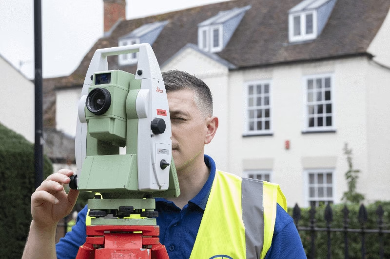
As surveyors, we visit your site with highly specialised equipment – Total Stations that measure distances to the millimetre, and GPS/GNSS rovers that pinpoint locations using satellite technology.
We do not rely on existing map data.
We measure the exact position of every feature on your site, right now, as it actually exists today.
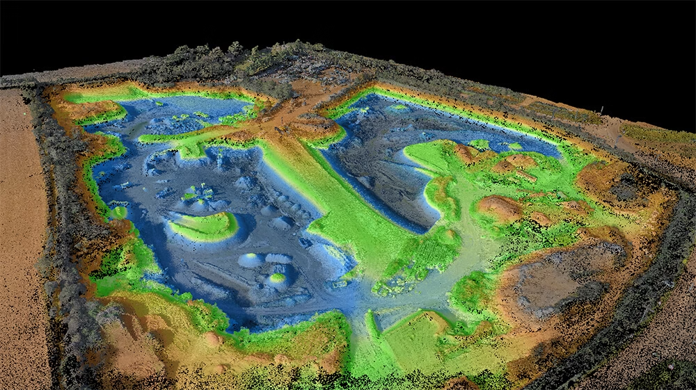
A typical topographical survey from Terrain Surveys captures between 500 and tens of thousands of individual data points per site. Our equipment achieves positional accuracy of ±10-20 millimetres – a far cry from the metre-plus tolerances of OS mapping.
This creates a brand new, highly detailed map. Some call it a “digital twin” of your specific parcel of land. Every tree, every drain cover, every subtle change in level is captured with scientific precision. After the fieldwork, our clients receive a CAD drawing in DWG format and a PDF plan, providing all the accurate geospatial data needed to move forward with confidence.
The Difference is in the Detail
Let us put these two products side by side.
Standard OS Map:
- An excellent guide for general planning
- Accuracy tolerances of ±0.9m to ±1.9m or more, depending on scale and age
- May not show recent changes
- Misses small but critical features
- Based on periodic updates, not current reality
Terrain Surveys Topographical Survey:
- A precise, legally robust measurement
- Accurate to the nearest centimetre
- Captures all features exactly as they are on the day of survey
- Shows every drain, service cover, and subtle level change
- Provides the confidence to build, knowing your data is spot-on
Think about that difference for a moment.
Up to two metres of tolerance versus the nearest centimetre.
That is like the difference between “somewhere in this room” and “exactly here, at this specific point.”
For architects, engineers, and developers, this is not just about precision – it is about avoiding costly errors that could derail entire projects.
A self-builder in Coventry experienced this first-hand. They had based their entire development design on OS data. When we surveyed the site, we found that the position of the site boundaries and neighbouring properties varied by between one and three metres. The practical consequence was that the proposed design encroached into neighbouring properties and had to be redesigned.
Our survey saved them significant costs by catching the problem before the project had progressed beyond the feasibility stage. Even more time and money would have been saved had a topographical survey been completed before the feasibility work began.

Who Needs Centimetre-Level Accuracy?
You might be thinking: “Surely not everyone needs this level of precision?”
You are right. If you are planning a countryside ramble, an OS map is perfect.
But for certain professionals and projects, centimetre accuracy is not a luxury – it is essential.
Architects & Developers
You cannot design a new building or extension based on a map that might be a metre or more out.
Think about it:
- Foundations need to be positioned exactly
- Drainage must connect to existing systems precisely
- Building lines and setbacks have legal requirements measured in centimetres, not metres
- Every connection point, every service run, every access route needs millimetre planning
Get it wrong, and you are looking at demolished work, planning violations, and furious clients.
Engineers
Planning infrastructure is not guesswork.
Whether you are designing drainage systems, calculating cut-and-fill volumes, or planning utility routes, you need precise topographical data that an OS map simply does not provide.
Being “roughly right” about levels could mean:
- Drainage that flows the wrong way
- Retaining walls in the wrong position
- Vastly miscalculated earthworks costs
Over the years, we have found that the features most often misrepresented on OS maps are boundary and building lines. This is because OS mapping is based on aerial imaging, and the direction of flight and weather conditions can result in mapping distortions – including missing data completely. For any project requiring accurate geospatial data, OS maps should only be used indicatively.
Homeowners
Here is something that surprises many of our clients: OS mapping was never designed to provide high-level accuracy. The most common area of confusion we encounter is the assumption that OS plans – and more specifically, title deed plans – are precise when they are merely an indication of what exists on the ground. We always explain to clients that a topographical survey is the starting point for confirming site sizes, measurements, and the position of boundaries.
You are in a boundary dispute. Or planning a significant extension near your property line. You pull up an OS map to prove your point.
Except OS maps show approximate boundaries, not legal ones. As the RICS Guidance Note on Boundaries (4th Edition, 2022) makes clear, title plans based on OS mapping indicate the general position of boundaries only and do not define their exact legal course.
Relying on an indicative OS map for a boundary dispute is risky. You need evidence that will stand up legally, measured to the centimetre.
Facilities Managers
Managing a large site without accurate mapping is like flying blind.
For planning site maintenance, new installations, or understanding utility routes, an up-to-date, accurate map is not just helpful – it is essential for efficiency and safety.
Imagine hitting an unmapped service because your map tolerances placed it a metre or more from where it actually sits. The costs, delays, and safety implications do not bear thinking about.
The Bottom Line
Ordnance Survey maps are an indispensable national resource. They are brilliant for understanding the broader picture, planning walks, and getting a general sense of an area.
But for any project where accuracy is critical, they are only the first step. Do not risk your project’s success on data with built-in tolerances of a metre or more.
Based on our 22 years’ experience surveying sites across the UK, we always advise clients to commission a topographical survey before submitting a planning application or starting design work. Any design work needs to be based on accurate geospatial data – without it, your designs have no value because you cannot design a project if you do not know the site constraints. The risk of proceeding without one is simply not worth it.
Whether you are breaking ground on a new development, resolving a boundary dispute, planning critical infrastructure, or designing an extension – you need certainty, not approximation.
Time and again, we see projects where designs have to be reworked because the OS data they were based on did not reflect the true positions on site. From proposed buildings that encroach beyond their intended footprint to access routes that fall foul of planning requirements, the consequences of relying on indicative mapping for detailed design work are costly and entirely avoidable.
A professional topographical survey from Terrain Surveys gives you the centimetre-level certainty you need to move forward with confidence. We offer a free, no-obligation quote and are always happy to provide professional advice to help you understand the right type of survey for your needs. The feedback we hear most often after completing a survey is clients thanking us for a professional and efficient service – and what they value most is that we always have an expert on hand to discuss project details.
Ready to move from “roughly right” to “precisely perfect”?