Before a single brick is laid, you need to know exactly what you’re working with.
Here’s a scenario we see play out more often than it should.
A developer commits to a site. An architect draws up plans. A contractor prices the job. Then, somewhere down the line, it turns out the ground levels weren’t quite right, the boundary sat two metres from where everyone assumed, or the building dimensions didn’t match the drawings.
What follows is expensive. Delays, redesigns, disputes, and sometimes legal action.
The frustrating part? Almost all of it was avoidable.
The solution isn’t complicated. It comes down to having accurate, reliable spatial data before any design work, planning application, or groundwork begins. And the instrument at the heart of that process (the one we rely on day in, day out at Terrain Surveys) is the Total Station.
If you’ve heard the term but aren’t entirely sure what it means, or you’re trying to figure out whether you actually need one for your project, you’re in the right place.
In this guide, we’ll walk you through exactly what a Total Station survey is, why it matters, who needs one, and how to find a reliable surveying team here in the UK.
Let’s start from the beginning.
What Is a Total Station Survey?

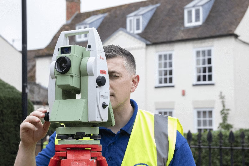
At its core, a Total Station is the workhorse of modern land and building surveying.
It’s an advanced optical instrument that combines two key technologies into one unit: an electronic theodolite, which measures horizontal and vertical angles with extreme precision, and an Electronic Distance Measurement (EDM) device, which uses a laser to calculate exact distances.
Put those two together, and you get a single instrument capable of pinpointing the precise position of any feature in three-dimensional space. It captures X, Y, and Z coordinates, measured to millimetre accuracy. For specialist structural monitoring, we can achieve sub-millimetre accuracy.
That level of precision isn’t just impressive. In UK construction and boundary mapping, where tolerances are tight and the consequences of errors are significant, it’s essential.
How Does It Actually Work?
The surveyor sets up the Total Station on a tripod at a known or measured position on site. From there, the instrument sends a laser beam towards a target. This is typically a reflective prism held by a second team member, or it can be fired directly to a surface in reflectorless mode – particularly useful for measuring features that are difficult or unsafe to physically reach.
Each measurement captures the angle and distance simultaneously, and the instrument calculates the precise coordinates automatically.
Modern robotic Total Stations take this a step further. They can be operated by a single surveyor. The instrument tracks a prism carried by the surveyor as they move around the site, recording measurements in real time. For large or complex sites, this makes the process significantly faster and more cost-effective.
What Happens to the Data?
Once the survey is complete, all of the captured data is downloaded and processed by our team. The output is typically a highly accurate 2D drawing or 3D CAD/BIM model, delivered in whichever format your project demands: DWG, PDF, Revit, and so on.
That processed data becomes the foundation everything else is built on. Quite literally.
Quality assurance is built into every stage of that process. On site, rigorous checks of survey data and equipment ensure everything is accurate and fit for purpose – our approach is very much ‘measure twice, cut once.’ Back in the office, secondary checks are undertaken on all control points and observations before processing begins. At each stage of the project, an experienced professional reviews the quality and accuracy of the data, and every commission undergoes a final QA check by a member of the senior management team – all of whom have over 15 years’ experience in their surveying specialism – before any drawings or models are issued to the client.
Why Are Total Station Surveys Essential?
Some clients come to us already convinced they need a survey. Others aren’t so sure, especially when budgets are tight and timelines are already under pressure.
So let us put it plainly: a Total Station survey isn’t a cost. It’s risk management.
Here’s why.
They Prevent Expensive Mistakes
Across our projects, the errors that cause the most damage – financially and professionally – aren’t the big, obvious ones. They’re the small inaccuracies that go unnoticed until it’s too late. What many clients don’t realise is that OS MasterMap data, while excellent for contextual reference, is not accurate enough for detailed planning or design work. It should be treated as indicative of site conditions only. For anything beyond that, a proper survey is essential to ensure you have up-to-date, accurate geospatial data as the foundation of your project. We regularly encounter situations where someone has relied on OS data or an outdated survey and found themselves in difficulty as a result.
A boundary that’s half a metre out. A floor level that doesn’t match the architect’s assumption. A structural element positioned slightly off-grid.
Individually, these sound minor. But by the time they surface on site, you’re looking at abortive work, material waste, contractor disputes, and in some cases, planning complications that set a project back by months.
A precise survey catches all of this before it becomes a problem.
They Save Time on Site
We often see clients who’ve tried to save money by skipping a proper survey, and ended up paying far more in the long run.
Modern robotic Total Stations mean a skilled surveyor can cover a substantial amount of ground quickly, working alone without the need for a second person to hold a prism. The data is captured efficiently, processed promptly, and delivered in a format your team can actually use.
Compare that to the time lost returning to site to re-check measurements, or worse, halting works mid-build while a dispute is resolved.
They Work in Virtually Any Conditions
This matters more in the UK than most places.
Total Stations are designed to operate indoors and outdoors, in daylight and low light, and in the kind of unpredictable weather conditions that are, frankly, just part of life in Britain.
In practice, the surveys that present the greatest logistical challenge are rarely large open sites. It’s occupied buildings – where we’re working around staff hours and daily operations – that require the most careful planning. In those situations, we work closely with the client or site occupant to formulate a plan of works that minimises disruption. That might mean working out of hours, deploying specific survey technology, or adapting our methodology to the environment. We have extensive experience operating in demanding settings that include schools, prisons, government buildings, foreign embassies, and busy industrial plants.
The Data Is Defensible
This point is underappreciated, but it matters enormously.
Survey data collected by a Total Station is precise, repeatable, and professionally produced. If a boundary dispute arises, if a contractor questions the drawings, or if a planning authority requires accurate site information, you have documented, accurate evidence to rely on.
That’s not something you get from a tape measure and a sketch.
Who Needs a Total Station Survey?
The short answer is: more people than you might think.
Total Station surveys aren’t exclusively for large infrastructure projects or commercial developments. We work with clients across a wide range of sectors, and in almost every case, the survey pays for itself before the project is finished.
Here’s how it breaks down.
Architects
If you’re designing from inaccurate or incomplete base data, you’re building on sand.
We provide architects with precise topographical surveys and measured building surveys that give you everything you need to design with genuine confidence. Accurate floor plans, ceiling heights, structural features, external levels, all captured to the tolerances your work demands.
In our experience, the architects who invest in a proper survey at the outset spend far less time revisiting assumptions or making site visits to double-check dimensions. The data is there. You can trust it.
Property Developers
For developers, a Total Station survey is often one of the first things we’d recommend before committing to a site purchase, let alone submitting a formal planning application.
Understanding the exact boundaries, the level changes across the plot, and the relationship between the site and surrounding features can make or break a feasibility assessment. We recently worked with a housing developer who was close to committing to a site. Our topographical survey revealed a significant level difference compared to the outdated survey they had been provided – a single finding that changed the viability of the scheme entirely and led to a renegotiated purchase price.
Get the survey done early. In our view, the survey should be the first professional instruction on any project, not the third or fourth. Without accurate geospatial data, any planning or design work is, at best, indicative. The architects and engineers who work from properly surveyed base data produce schemes that hold up. Those who work from assumptions often come back to us further down the line.
Civil and Structural Engineers
Engineers rely on Total Station data at multiple stages of a project.

At the design stage, accurate ground and feature data feeds directly into calculations and modelling. During construction, the process of setting out (transferring the design coordinates from drawings onto the physical ground) requires the same precision the Total Station delivers.
And once a structure is built, Total Stations are used to verify that the finished build was done exactly to specifications.
Facilities Managers
If you’re responsible for managing a commercial or public building, accurate spatial data is the foundation of effective asset management.

We regularly produce as-built floor plans for facilities teams, capturing the current state of a building rather than relying on outdated original drawings that may no longer reflect what’s actually there. We also calculate Net Internal Area (NIA) and Gross Internal Area (GIA) to RICS standards, which is critical for lease agreements, valuations, and space planning.
Having accurate, up-to-date plans isn’t just useful. In many cases, it’s a professional and contractual requirement.
Homeowners
You might not expect to see homeowners on this list, but there are situations where a Total Station survey is genuinely the right call.

Planning a significant extension that requires accurate site levels and boundary positions? It’s worth doing properly. Undertaking a major landscaping project where drainage, gradients, and levels need to be carefully managed? The same logic applies – get the levels wrong at the start, and you can end up with drainage flowing the wrong direction, or hard landscaping that has to be ripped up and relaid.
And if you’re involved in a boundary dispute with a neighbour, a professionally produced survey provides indisputable, factual data. In our experience, having accurate survey evidence often resolves these situations far more quickly (and far less expensively) than a prolonged legal argument based on assumptions and remembered conversations about where a fence once stood.
Where to Get a Total Station Survey in the UK
The equipment itself is only part of the story.
Most professional surveying firms will have access to a Total Station. What separates a good survey from a great one isn’t the instrument – it’s the expertise of the people using it, and the quality of the data they deliver.
Here’s what to look for when choosing a surveying partner in the UK.
Look for Accredited, Experienced Professionals
Surveying is a discipline where experience genuinely counts.
When you’re evaluating firms, look for ICES (The Institution of Civil Engineering Surveyors) membership. They set the professional standards that reputable UK surveying practices work to. It’s a reliable indicator that the company takes accuracy, methodology, and professional conduct seriously.
Beyond accreditation, ask about sector experience. A surveyor who has worked extensively on heritage buildings understands the particular challenges they present. One with a strong commercial development background will understand what a planning authority expects to see. The right firm brings relevant expertise, not just a piece of kit and a set of coordinates.
If we were advising someone choosing a surveying firm for the first time, we’d focus less on price and more on sector experience and the quality of the deliverables the firm can demonstrate. The Total Station is a tool – what matters is knowing what to measure and how, where the critical reference points are, and how to present that data usefully. That comes from experience, not equipment alone.
Ask About Data Deliverables Upfront
One thing we always encourage clients to think about before commissioning a survey is: what format do you actually need the data in?
Your architect may require a DWG file. Your structural engineer might need a Revit model. Your planning consultant may simply need a clean, georeferenced PDF.
A good surveying firm will ask these questions before they set foot on site, and deliver data in the exact format your project team can use straight away, without the added burden of conversion or reformatting. If a firm hasn’t asked what format your design team needs before they arrive on site, treat that as a warning sign – it suggests they may be working from a template rather than genuinely understanding your project.
Consider Coverage and Capacity
If your project spans multiple sites, or you’re working across different regions of the UK, it’s worth choosing a firm with genuine national coverage rather than one that operates primarily in a single area.
Continuity of surveyor, consistent methodology, and a single point of contact make a meaningful difference, particularly on larger or longer-term projects.
Why Clients Choose Terrain Surveys
At Terrain Surveys, we’ve invested significantly in the latest robotic Total Station technology, and in the training and development of our surveying teams. We cover the whole of the UK, from greenfield development sites to complex, occupied heritage buildings, and we bring decades of hands-on experience to every project we take on.
One of the most significant shifts we’ve seen over our years in practice isn’t the instruments themselves – it’s the expectation around deliverable formats. A decade ago, 2D CAD drawings were the standard output, with many clients requesting hard copies sent by post. Today, a growing number of clients request 3D models as a matter of course. It’s a change that reflects how project teams are working, and we’ve developed our capability to meet it.
What that means in practice is straightforward. Accurate data, delivered in the format you need, on time and on budget.
We work with architects, developers, engineers, facilities managers, and homeowners alike. Whether your project is large or small, straightforward or technically demanding, we take the same approach: thorough, precise, and focused entirely on giving you data you can actually rely on.
We also understand that many clients come to us early in the process, sometimes before they’re entirely sure what they need. The question we’re asked most often at the enquiry stage is: what’s the difference between a topographical survey and a measured building survey? It tells us that many clients are working without a fully formed brief – which is absolutely fine. Helping you understand exactly what survey is right for your project, with no obligation attached, is part of what we’re here for.
A Precise Survey Is an Investment That Pays for Itself
Every project, whether it’s a residential extension, a commercial development, or a complex infrastructure scheme, begins with a set of assumptions about the site. The question is whether those assumptions are based on guesswork, or on accurate, professionally captured data.
The cost of getting that wrong isn’t abstract. It shows up in abortive design work, contractor disputes, planning delays, and expensive on-site corrections. We see it happen regularly. And in almost every case, it traces back to the same root cause: not having survey data at the start of the project.
A Total Station survey eliminates that risk. It gives your entire project team (architects, engineers, contractors, planners) a single, trusted source of spatial truth to work from. Everything downstream becomes more efficient, more accurate, and more defensible as a result.
Talk to Our Team: No Obligation
If you’re at the early stages of a project and you’re not sure what you need, that’s precisely the right time to get in touch.
At Terrain Surveys, we offer a free, no-obligation quote and genuinely free professional advice. We’ll listen to what you’re working on, ask the right questions, and give you a clear, honest recommendation – whether that leads to a commission with us or simply points you in the right direction.
No sales pressure. No jargon. Just straightforward expertise from a team that has been doing this for a long time.
To get started, visit our contact page and drop us a message. We’ll get back to you promptly.
The foundation of every successful project is knowing exactly what you’re working with. Let’s make sure yours is built on solid ground.


