Cookie Consent by Free Privacy Policy Generator

Topographical Surveys Manchester

Manchester is one of the most active development markets in the country, and one of the most demanding to survey accurately. Tight city-centre plots, dense Victorian terraced grids, mills mid-conversion, brownfield land still being reshaped, and a flow of build-to-rent and mixed-use towers all sit on top of a complicated drainage and made-ground story.

At Terrain Surveys we deliver precise, dependable topographical surveys for architects, engineers, developers and contractors across Greater Manchester — from Ancoats, NOMA and the Northern Quarter, through Salford’s riverside, MediaCityUK and the Quays, out to Didsbury, Chorlton and the airport corridor. Since 2004 we have completed more than 10,000 topographical surveys across Britain, around 1,000 each year, so the kind of plot you are working on we have almost certainly surveyed before.

What Manchester clients consistently rate about our service:

  • Fast mobilisation across Greater Manchester and the North West
  • Deep experience with brownfield, mills, warehouses, terraces and tight city-centre plots
  • Clear, competitive pricing and free quotes — no hidden extras
  • ISO 9001 certified quality systems
  • 2D CAD outputs and BIM-ready 3D / point-cloud models from a single visit
  • Senior management QA sign-off on every project before issue
5.0
powered by Google
Call us today
+44(0)143 884 1300

Get a free quote

Request a free, no-obligation quote for your project today.

Max. 5MB images, .dwg, .dxf, .docx, or .pdf files only.

    What A Topographic Survey Is — And When Manchester Projects Need One

    A topographic survey is the measured baseline drawing of your site. Levels across the plot. True boundary positions. Building footprints, party walls, kerbs, trees, drainage covers, surface services. The detail that decides whether a scheme fits, drains, costs the budget you priced, and gets through planning.

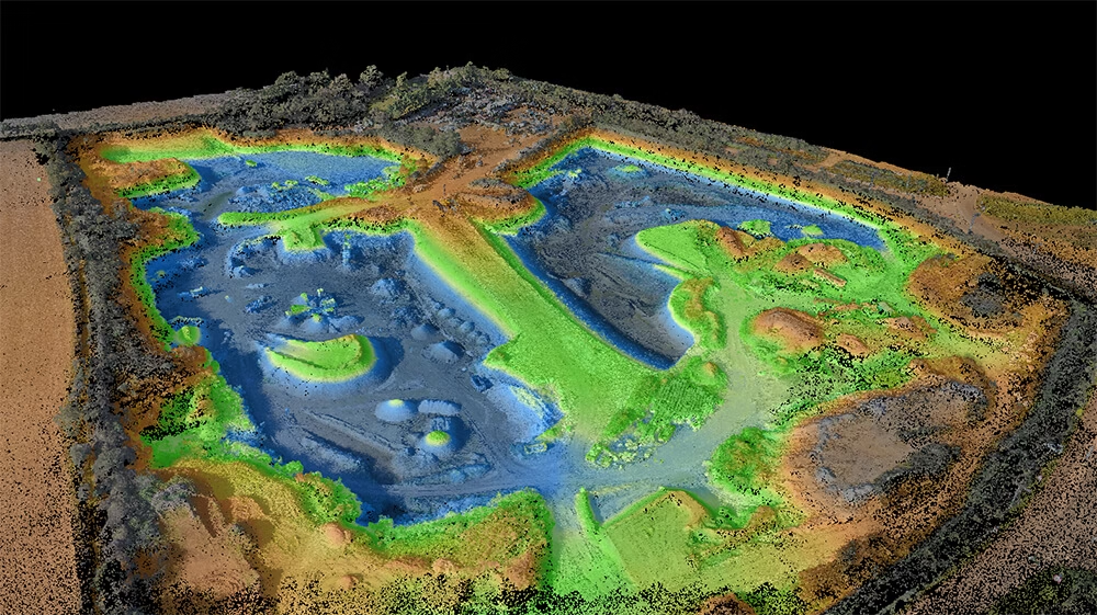
    On a typical site we capture between 500 and tens of thousands of measured points, with positional accuracy verified to within ±15 mm of independent control. On a medium-sized commercial development we can capture millions of measured points in a single day’s fieldwork using our modern scanning equipment. A standard topographical survey is usually completed in around 8 hours on site, depending on complexity.

    Manchester projects that should start with a topographic survey:

    • Build-to-rent, PRS and mixed-use schemes on tight city-centre plots
    • Mill and warehouse conversions in Ancoats, Castlefield, New Islington and the Northern Quarter
    • Residential extensions, infill and replacement dwellings across the boroughs
    • Brownfield regeneration plots where ground levels have been heavily modified
    • Planning applications to Manchester, Salford, Trafford or Stockport councils
    • Flood-risk and SuDS submissions on river and canal-fronted sites
    Measuredbuildingsurveycoventgardenlondon

    Surveying Dense Urban Infill & Brownfield Manchester

    The tricky part of surveying Manchester isn’t the kit. it is the context. City-centre plots wedged between live buildings, mill conversions where the floor plates have been remodelled three or four times, and post-industrial brownfield where what looks like “ground” is actually decades of demolition fill. None of that reads accurately from Ordnance Survey data alone.

    Across the ~1,000 projects we handle each year, around half of all sites reveal at least one discrepancy between assumed and actual conditions – most often in boundary positions and ground levels. On Manchester sites that translates directly into design risk: a wall set 300 mm too far, a slab set to the wrong level, or a drainage strategy that doesn’t fall the way the design assumed.

    A properly executed topographic survey gives a Manchester design team:

    • True levels for slab, foundation, drainage and SuDS design on made-ground sites
    • Verified boundary positions and building lines on tight, party-walled plots
    • Accurate location of trees, kerbs, drainage covers and access points
    • Levels referenced to Ordnance Datum, suitable for flood-risk and surface-water modelling
    • A single base drawing shared by architect, structural, M&E and contractor
    • Point-cloud and BIM outputs where the scheme demands them, from the same site visit

Planning a construction Project?

Planning a construction project without an accurate topographical survey can lead to design errors, drainage problems, setting-out issues and expensive delays once work is under way. Terrain Surveys helps you avoid costly mistakes before they become site problems, giving your team the reliable data needed to plan with confidence, so speak to us today for a free, no-obligation quote.

Contact Us
    Land topographic drone surveys

    When A Cheap Survey Costs You 10× More

    Manchester is competitive at the procurement stage and the temptation to take the cheapest survey quote is real. Based on 22 years in the industry, the single biggest procurement mistake we see is accepting the lowest price.

    When clients come to us after a failed or insufficient survey by another provider, the average cost of remediation — emergency resurveys, contractor delays, redesign, and rework — is approximately 10× the original survey cost.

    The pattern is the same almost every time: operators with impressive-looking drones and scanners but no survey-grade equipment, no survey control, and no real surveying background. The resulting models look fine on screen, then on closer inspection the buildings are the wrong shape, doors and windows are the wrong size, and levels are off.

    The failure modes we see most often on Manchester sites without a proper survey:

    • Revit or BIM models with drifted geometry that survives until detail design — then fails
    • Drainage and SuDS strategies built on assumed levels, requiring late-stage redesign
    • Extensions or new builds drawn on the wrong boundary line and needing to be redrawn
    • Planning applications delayed or invalidated by the wrong Ordnance Survey product
    • Emergency resurveys mid-construction — the most expensive moment to discover the problem
    • Programme delays of two weeks minimum, something which a proper survey up-front would have avoided

    Why Manchester Developers Choose Terrain Surveys

    Choose a surveyor on sector experience and the quality of the deliverables they can show you, not on price. The total station, the GNSS receiver and the laser scanner are tools. What matters is knowing what to measure, where to set the control, and how to present the data so your design team and your contractor can actually use it. That comes from experience, not equipment alone.

    Our QA process starts on site. We are very much measure-twice-cut-once. With rigorous checks on data and equipment before we leave. Back in the office, secondary checks are run on all control points and observations before processing begins. Every project then runs through a final review by a member of our senior management team (all of whom have over 15 years of experience in their specialty) before anything is issued. Internal QA verifies measured points to within ±15 mm of independent control.

    What Manchester architects, project managers and contractors consistently tell us:

    • Fast, clear answers at the enquiry stage — no surveyor jargon
    • Quicker mobilisation than they were expecting
    • A noticeably higher level of detail in the deliverable than they have had before
    • A point of contact who is genuinely available throughout the project
    • A design process that runs smoother off the back of trustworthy data
    • A 4-bed detached house typically surveyed in 3–4 hours, with full CAD deliverables inside 5 working days
    Hertfordshire inside out
    Area covered by our team in Welwyn, Hertfordshire.

    We Know Manchester Inside Out

    Manchester is a city that keeps moving. New plots open up between live buildings in the centre. Mills get reborn as flats, then re-planned as offices, then reborn again. Districts you wouldn’t have considered 10 years ago are now the front line of development. The one constant is that every successful scheme starts with somebody knowing exactly what is on the ground.

    We have surveyed enough of the North West to anticipate what a Manchester site is likely to throw up before we are on it — made ground over old foundations, drainage from earlier phases that doesn’t match the record drawings, party walls of every conceivable construction, and planning officers who expect accurate, well-presented base data. That preparation is what lets us turn projects around quickly without cutting corners.

    Ready to talk about your Manchester site? Get in touch for a free, no-obligation quote and we will be on site quickly, with a survey your design team can actually build from.

Combined Surveys

We can combine other types of surveys with your topographical survey to provide an even richer output. Whether you require underground utility mapping data, measured building surveys layered into your topographical project or the inclusion of a CCTV drainage condition and connectivity survey, we can help.

    Type D Desktop utility record search

    Utility Mapping Surveys

    If you’re planning, designing or pricing works, a site-wide utility survey gives you a clear picture of what’s underground across the full area. This helps you avoid design clashes, plan routes for foundations and drainage, and reduce expensive last-minute changes once works are underway.

    Read More
    Revit Technician

    Measured building Surveys

    Need a precise, professionally delivered measured building survey? At Terrain Surveys, we provide detailed floor plans, elevations, and cross-sections for buildings of every type, from historic properties and private homes to large commercial sites and public facilities.

    Read More
    Cctvcrawlercamerainuseforconditionconnectivitysurvey

    CCTV Drainage Condition & Connectivity

    Need accurate and up to date information on your drainage system? We have you covered. Using advanced camera equipment and decades of experience, we can investigate and map below ground drainage infrastructure.

    Read More

Our work

From our main offices in Hertfordshire and Birmingham, we've carried out thousands of topographical surveys across the UK. Browse our project case studies below or get in touch with our team to discover how we can help you.

Accreditations

We'd love to hear from you

Get a free quote ONLINE OR CALL

+44(0)143 884 1300

Request a free, no-obligation quote for your project today.

Max. 5MB images, .dwg, .dxf, .docx, or .pdf files only.

Processing...
Thank you! Your subscription has been confirmed. You'll hear from us soon.
ErrorHere