Imagine having a highly accurate digital version of your building or site – one you can explore on screen, measure from, and interrogate in detail before a single new design drawing is produced. What if you could walk a site virtually, check clearances, and identify clashes or constraints without leaving your desk?
This isn’t science fiction – it’s exactly what modern 3D surveying delivers.
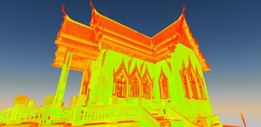
Using 3D laser scanning, surveyors capture millions (often billions) of precise measurements to create what’s known as a point cloud. At Terrain Surveys, we use this technology every day to give architects, engineers, contractors, and property owners a reliable digital record of their sites and structures.
In this article, we’ll explain what a point cloud is, how we create one, and the key benefits it can bring to your project – whether you’re planning a major commercial development or a small but complex home extension.
What Exactly is a Point Cloud?
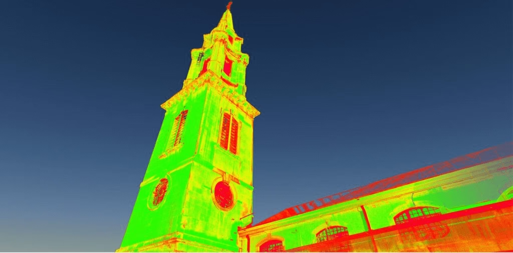
A point cloud is best thought of as a three-dimensional “connect-the-dots” survey of the real world.
A 3D laser scanner measures the distance to surfaces around it, capturing millions of individual points. Each point has precise coordinates in space (X, Y, and Z). When you view all of these points together, they collectively form a highly detailed 3D representation of a building, structure, or site.
It’s a bit like taking a photograph – but instead of just capturing colour and light, you’re capturing exact positions and distances.
From a technical point of view, a point cloud is a dense collection of measured points representing the external surfaces of an object, building, or environment. Each point carries:
- Spatial coordinates (X, Y, Z)
- Often colour information (RGB values) taken from integrated cameras
- Sometimes intensity values, showing how strongly the laser signal was reflected
This raw survey data is then used as the foundation for creating accurate 2D drawings, BIM-ready 3D models, sections, elevations, and other deliverables.
The real strength of point cloud data lies in its flexibility. Once captured, it can be sliced, queried, and transformed in many ways to support your project – from quick checks and clash detection to full as-built modelling and long-term asset records.
How We Create a Point Cloud
Creating a point cloud isn’t just about pointing a scanner at a building and pressing a button. It’s a carefully orchestrated process that combines cutting-edge technology with surveying expertise.
The Technology

At Terrain Surveys, we use state-of-the-art 3D laser scanners, also known as High-Definition Surveying (HDS) equipment. These incredible bits of kit can capture data at speeds of up to 2 million points per second.
A full dome scan can be completed in minutes, capturing everything visible from that position with an accuracy that is typically within ±2-5mm. That level of precision is simply impossible with a traditional tape measure.
The Process: On-Site
Step 1: Scoping before we even arrive on site. Our team discusses your project requirements to determine the level of detail needed. Are you planning a simple extension? Or are you coordinating complex MEP installations in a heritage building? The scope determines our approach.
Step 2: Strategic planning once on site. We identify the optimal scanning positions and establish robust control networks to ensure all data captured is accurate and fit for purpose. We need to ensure complete coverage whilst minimising scan time and avoiding data gaps or “shadows.”
Step 3: Data capture. Our trained surveyor sets up the scanner on a tripod at multiple strategic locations around the site, both internally and externally. The scanner rotates, emitting a laser beam that measures millions of points per second, capturing everything in its line of sight.
Multiple scans are essential.
Why? Because no single position can capture everything. Think of it like photographing a room-you need multiple angles to see behind furniture or around corners.
The Process: In the Office
Step 1: Registration back in our office. We use specialist software to “stitch” the multiple scans together into a single, cohesive point cloud. This process, called registration, aligns all the individual scans using common reference points.
Step 2: Processing and cleaning. The raw point cloud often contains “noise”-perhaps a person walked through during scanning, or there’s vegetation moving in the wind. We clean this data, removing unwanted elements whilst preserving all the crucial structural information.
Step 3: Delivery. The final registered point cloud can then be delivered to you in various formats, compatible with industry-standard software like Autodesk Revit and AutoCAD. Or, we can use it to produce specific deliverables like 2D CAD drawings, 3D wireframe models, or full BIM models.
The Key Benefits of Point Cloud Data
Let’s get straight to the question on your mind: how does this actually help you?
In practical terms, point cloud surveys give you four big wins: 3D insight, accuracy, speed, and safety.
- 3D: You get a complete, measurable 3D representation of your site or structure, not just flat drawings. That means better design coordination, clash detection, and clearer communication with your team and stakeholders.
- Accuracy: Modern laser scanners capture millions of points with millimetre-level precision, giving you a reliable digital record you can trust for design, planning, and verification.
- Speed: Large areas can be scanned quickly, reducing time on site and helping you move faster from survey to design and then to construction.
- Safety: Much of the data can be captured from the ground or at a distance, reducing the need for working at height, accessing confined spaces, or entering hazardous areas.
Now, let’s break down what these benefits mean in practice for your projects and workflows.
For Architects & Engineers
Unrivalled Accuracy
High-quality laser scanning typically achieves accuracy within a few millimetres under normal site conditions. That level of precision significantly reduces guesswork. When you’re designing a complex steel frame, coordinating MEP services in a tight ceiling void, or checking tolerances around existing structures, this accuracy helps you design with confidence and reduces the need for re-work.
Reliable As-Built Record
A point cloud gives you a highly accurate “as-is” digital record of the existing building or site before design begins. This is especially important on refurbishment, retrofit, and change-of-use projects, where existing drawings are often incomplete, out of date, or missing altogether. Time and again, we see that the built reality differs from legacy plans; point clouds provide an evidence-based starting point for your design.
Early Clash Detection
Once the point cloud is converted into a 3D model (Revit, Archicad, etc.), you can test new designs against the existing structure and services. This makes it far easier to identify clashes and access issues at the design stage, rather than discovering them on site. Resolving these issues early can avoid programme delays and change costs that may otherwise run into tens of thousands of pounds.
BIM-Ready Data
Point clouds are an ideal foundation for developing coordinated 3D and BIM models. They support workflows aligned with the UK BIM Framework by providing accurate geometric information for as-built or existing-condition models. This helps you deliver better coordination, clearer information exchange, and more collaborative working with the wider design and project team.
For Property Developers & Facilities Managers
Reduced Project Risk
By starting with a precise digital survey of existing conditions, you significantly reduce the risk of “unknowns” during construction. Point clouds help uncover structural constraints, level changes, and services routes before work starts on site, supporting more reliable cost plans, fewer unexpected variations, and tighter control over programme.
Better-Informed Decisions
Accurate 3D data underpins reliable area calculations (including GIA and NIA), space planning, feasibility studies, and asset management. When you’re assessing rental yields, planning fit-outs, or evaluating refurbishment options, precise measurements and verified geometry give you a sound basis for commercial decisions.
Foundation for a Digital Twin
A point cloud can be the first step towards a true “digital twin” of your asset. Once modelled, you have a detailed digital representation that supports facilities management, planned maintenance, and future refurbishments. Need to check clearances, plant locations, or access routes? In many cases, you can do it from your screen rather than arranging a site visit.
Improved Project Efficiency
Modern laser scanners can typically capture an entire building or site in days rather than weeks, depending on size and complexity. The data is quickly processed into usable formats for your consultants, shortening the survey-to-design phase and supporting faster project mobilisation without compromising on accuracy.
For Homeowners
Peace of Mind for Extensions & Renovations
If you’re planning an extension, loft conversion, or internal reconfiguration, a point cloud survey provides very accurate base drawings for your architect and structural engineer. That means designs are based on real dimensions, not assumptions, helping to ensure that what’s approved on paper will actually fit on site.
Support for Rights of Light & Boundary Issues
Where rights of light assessments, party wall matters, or complex boundary questions arise, 3D laser scanning can capture existing conditions with a high degree of accuracy. The resulting drawings and models provide clear, measured information that can be used by your professionals when preparing reports or negotiating with neighbours.
Clarity for You and Your Builder
Everyone involved – homeowner, architect, engineer, and contractor – works from the same accurate set of plans. That reduces ambiguity, minimises misunderstandings, and helps avoid disputes about what was or wasn’t shown on the drawings once work is underway.
Real-World Applications
Heritage & Listed Buildings
On listed and historic buildings (including Grade II and above), point clouds allow you to capture intricate details – such as mouldings, cornices, arches, and irregular stonework – without intrusive investigation. Because data is often captured from a distance, it reduces physical contact with delicate fabric and supports conservation-led design.
Industrial & Manufacturing Facilities
In busy industrial environments, laser scanning can be carried out from safe vantage points or, where appropriate, using drones. This reduces the need for working at height or close to operating machinery. Detailed point clouds capture pipe runs, structural frames, conveyors, and plant layouts so you can plan upgrades, rerouting, or new installations while keeping operations running.
Urban & City-Centre Development
For tight urban sites, point clouds can include not only your building but also neighbouring properties, street furniture, kerb lines, and surrounding topography. This level of context is invaluable for rights of light and overshadowing studies, crane and logistics planning, façade retention schemes, and the detailed topographical surveys needed to understand how your development will sit within the existing streetscape.
The Deliverables: More Than Just Points
The point cloud itself is just the beginning. From this rich dataset, an expert team of technicians, such as ours, can produce:
- 2D CAD Drawings (Floor Plans, Elevations, Sections)
- 3D Wireframe Models
- 3D BIM Models (Revit, ArchiCAD compatible)
- Topographical Surveys
- Volumetric Calculations
- Deformation Analysis
Each deliverable serves a specific purpose in your project workflow. We’ll advise on exactly what you need.
Ready to Bring Certainty to Your Project?
Point cloud technology has revolutionised how we capture and understand the built environment. It offers unprecedented accuracy, comprehensive coverage, and versatile outputs that support modern construction and design workflows.
But technology is only part of the equation.
Our expert team is always on hand to provide free, professional advice for your specific needs.
We’ll help you understand exactly what type of survey will deliver the best value for your project, whether that’s a full point cloud survey, a traditional Measured Building Survey, or a hybrid approach.
Don’t leave your project’s success to chance.
Contact us today for a no-obligation quote and let’s discuss how we can bring certainty to your next project.

