Ever started a renovation project only to discover the walls aren’t where the old drawings said they’d be?
Or watched a construction budget balloon because nobody spotted that steel beam running through the proposed new doorway?
Here’s the thing: working from outdated 2D drawings or manual measurements is like navigating London with a map from 1985. You might get there eventually, but you’ll hit plenty of unexpected roadblocks along the way.
That’s where Scan to BIM comes in – and it’s completely transformed how we approach building projects.
First, A Quick Refresher: What is BIM?
Before we dive into the scanning bit, let’s clear up what BIM actually means.
Building Information Modelling (BIM) isn’t just a fancy 3D model. It’s an intelligent digital process that’s revolutionised construction and design, championed by frameworks like the UK BIM Framework.
Think of the difference between a simple sketch of a car and a full engineering model. The sketch shows you what it looks like. The engineering model tells you everything – the materials, how the engine connects, the weight distribution, even the maintenance schedule.
That’s BIM for buildings.
Every component in a BIM model ‘knows’ what it is. A wall isn’t just a line – it contains data about its materials, dimensions, fire rating, acoustic properties, and even its maintenance history.
It’s a collaborative tool that architects, engineers, contractors, and facilities managers use throughout a building’s entire lifecycle. From initial design to demolition decades later.
So, What is Scan to BIM?

Scan to BIM is the process of using high-definition 3D laser scanners to capture the precise details of a physical building or site (the ‘Scan’), then using that data to create an accurate, intelligent Building Information Model (the ‘BIM’).
In simple terms?
We’re creating a perfect digital replica – a ‘digital twin’ – of your real-world space.
At Terrain Surveys, we see this as the bridge between the as-built world and the future of digital design. It’s about bringing existing buildings into the digital age, giving you the same powerful tools for renovation projects that new builds have enjoyed for years.
How It Works: Our Step-by-Step Process
Let me walk you through exactly how we turn a physical building into a digital asset.
Step 1: The Consultation & Scoping
This is where we sit down with you to understand your goals.
What will the model be used for? Design work? Clash detection? Facilities management?
This determines the Level of Detail (LOD) required. The LOD scale defines how much detail gets modelled, from a basic massing model (LOD 100) to a highly detailed model with every nut and bolt (LOD 500).
We help you choose the right level, so you’re not paying for unnecessary detail – but you’ve got everything you need for your project.
This initial advice? It’s completely free. So, get in touch if you’re not sure what LOD you need.
Step 2: The Scan – Capturing Reality
Our surveyors visit your site with advanced 3D laser scanners.
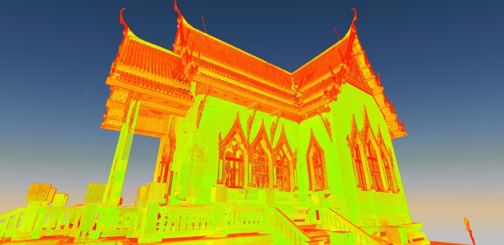
The scanner rotates 360 degrees, sending out millions of laser pulses per second. Each pulse measures the exact distance to whatever it hits – walls, pipes, beams, fixtures. This creates a dense 3D map called a ‘point cloud’.
We take multiple scans from different positions to capture the entire space from all sides. Complex areas might need dozens of scan positions. Every corner, every service run, every structural element gets captured.
All our site staff hold valid CSCS cards, and we’ve invested in the latest scanning technology for maximum efficiency and accuracy. A typical office floor that might take weeks to survey manually? We can scan it in hours, and we can do so to a level of accuracy that would be impossible for a person with a measuring tape.
Step 3: Registration – Stitching the Data Together
Back in the office, we use specialist software to ‘stitch’ all those individual point cloud scans together. This creates one complete, cohesive 3D dataset of your entire building or site. Think of it like assembling a massive 3D jigsaw puzzle – except each piece contains millions of measurement points.
The registration process ensures everything aligns perfectly, giving you millimetre-accurate data across the entire project.
Step 4: The Modelling – Building the Intelligence
This is where the magic happens.
Our expert technicians use the registered point cloud as a precise template to build the BIM model in software like Autodesk Revit.
But this isn’t just tracing. It’s interpretation.
We’re turning raw spatial scan data into intelligent objects – walls that know they’re walls, doors that know their fire ratings, pipes that know their diameters and materials.
This is where the experience of our team really shines. They understand construction. They know what they’re looking at. They can spot a steel beam from a concrete one, identify service runs, and model complex geometries accurately.
The result? A fully intelligent BIM model that’s not just a pretty picture – it’s a powerful tool for your project.
The Benefits: Why This Matters for Your Project
Now, let’s talk about what this actually means for you.
Because the benefits change depending on who you are and what you’re trying to achieve.
For Architects & Engineers
Unmatched Accuracy
Manual surveys introduce human error. It’s inevitable.
But laser scanning? It captures millions of measurements with millimetre precision. You’re designing from reality, not approximation.
That means your designs fit perfectly the first time. No nasty surprises when construction starts.
Clash Detection Before Breaking Ground
Here’s where BIM really earns its keep.
The model can identify where your new designs will clash with existing structures before anyone picks up a hammer.
That new ventilation system? The software will tell you if it’s going to hit a beam. Those additional pipes? You’ll know exactly where they can and can’t go.
Finding clashes in the model costs nothing. Finding them on-site? That’s when budgets explode.
Time Savings That Add Up
Think about the hours your team currently spends on-site, measuring, sketching, photographing.
With Scan to BIM, site visits drop dramatically. Need to check a dimension? It’s in the model.
Want to see how services run through a ceiling void? It’s all there.
For Property Developers
Risk Reduction That Pays for Itself
Every developer knows that feeling. The contractor calls. They’ve found something unexpected.
The budget needs adjusting. Again.
Scan to BIM virtually eliminates these surprises.
You’ll know about that hidden steel frame. The unusual floor construction. The services running where they shouldn’t. All discovered in the comfort of your office, not halfway through demolition.
Budget & Schedule Certainty
Fewer surprises mean fewer variations. Fewer variations mean your budget stays on track.
Industry studies suggest that BIM can lead to significant cost savings.
When you can plan properly, coordinate trades effectively, and avoid rework, projects run smoother. Contractors can price accurately. Timelines become reliable.
Your investors will thank you.
For Facilities Managers
The Ultimate As-Built Record
How many times have you needed to find a valve, check a cable run, or plan maintenance work – only to discover the drawings are wrong?
A Scan to BIM model gives you a perfect ‘digital twin’ of your building. Every pipe, every cable tray, every plant item, exactly where it actually is.
Planning a refurbishment in five years? The model’s waiting. Need to brief a maintenance contractor? Send them the model. Managing space allocation? It’s all there and it’s all accurate.
Efficient Space & Asset Management
The model isn’t just geometry – it’s data.
Every asset can be tagged with maintenance schedules, warranty information, and specifications. You can run reports, track equipment lifecycles, and optimise space usage.
It transforms reactive maintenance into proactive management.
For Homeowners
Peace of Mind for Major Renovations
Planning a large extension or significant remodelling?
Your architect needs accurate information to design properly. Working from old plans or their own measurements introduces risk – your risk.
With Scan to BIM, they’re working from perfect data. That dream kitchen extension? It’ll fit exactly as planned. The loft conversion? No surprise beams blocking the stairs.
Avoiding the Nightmare Scenario
We’ve all heard the horror stories.
The wall that turned out to be load-bearing after it was half demolished. The pipe that appeared where the new window was meant to go. The floor levels that weren’t quite what everyone thought.
These surprises don’t just cost money – they cause stress, delays, and sleepless nights.
A proper scan eliminates these nightmares before they begin.
Common Concerns (And Why They’re Overblown)
“It sounds expensive”
Compared to traditional measured building surveys? The cost difference is marginal.
Compared to the cost of getting it wrong? It’s a bargain.
Most clients find Scan to BIM pays for itself just through the variations it prevents. Everything else – the time savings, the improved coordination, the better outcomes – that’s pure bonus.
“We don’t need that much detail”
That’s exactly why we scope projects properly.
You don’t need LOD 500 detail for space planning. You don’t need every bolt modelled for a basic refurbishment. We’ll recommend the right level of detail for your specific needs.
You pay for what you need, nothing more.
“Our building is too complex”
Actually, complex buildings benefit most from Scan to BIM.
Traditional surveys struggle with complexity. They miss things. They simplify. They approximate.
Laser scanning captures everything. Complex geometries, unusual construction, intricate services – it all gets recorded. Our modellers have seen it all. Listed buildings, industrial facilities, healthcare complexes – complexity is what we do best.
Build with Certainty
Here’s what it comes down to:
Scan to BIM is an investment in accuracy that pays for itself by reducing risk, saving time, and preventing costly errors.
It’s the difference between hoping your project goes smoothly and knowing it will.
At Terrain Surveys, we’ve built our reputation on quality, integrity, and client satisfaction. We’re backed by accreditations like ISO 9001, and are proud members of the Chartered Institution of Civil Engineering Surveyors (CICES) and The Survey Association (TSA) – but what really matters is that we deliver results.
We don’t just provide data. We provide certainty.
Whether you’re planning a complex commercial development or a major home renovation, starting with an accurate picture of your property is the most critical first step.
Contact us today for a free, no-obligation quote.
We’ll provide professional advice on the right approach for your project.
Because when you’re investing thousands – or millions – in a building project, starting with accurate data isn’t just smart. It’s essential.