
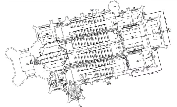
CAD Surveys: What Are They & Who Can Do Them For You?
A client rang me once, three weeks into a design programme, to ask why the “CAD survey” he had paid for could not be opened by his architect. It turned out he had been sent a PDF. A perfectly good PDF as it was exported from the CAD file, but a PDF is limited and is not suable for measurements or interrogation of data, simply put – its an image of the CAD drawing. You cannot snap to it, you cannot trace levels off it, and you certainly cannot build a model on it.
What is a CAD survey?
A CAD survey is a measured survey of a site or building where the deliverable is supplied as a computer-aided design file, rather than as a paper plan or a digital image.
The important word there is deliverable. CAD is not a way of surveying. It is the format the survey arrives in.
The measuring itself might be done with a total station, GPS, a 3D laser scanner, or some combination of all three, depending on the site. What makes it a CAD survey is that the finished drawing is an intelligent, editable, dimensionally correct file that your design team can work inside.
Did you know?
The same site data can be issued in several formats at once. A single topographical survey can produce a 2D CAD plan for planning drawings, a 3D model for earthworks calculations, and a PDF for circulation to non-technical stakeholders. Ask for what you need up front and there is rarely an extra visit involved.
Why does the format matter so much?
Because everything downstream depends on it.
Your architect draws on top of the survey. Your structural engineer takes dimensions from it. Your civils team calculates cut and fill from the level data. Your planning consultant produces site plans from it. If the base file is not workable, every one of those people cannot perform their role with confidence. You cant simply trace over a pdf and produce an accurate CAD drawing, the initial survey will need to be re-done.
I have seen projects delayed by weeks due to clients realising to late that they do not have CAD plans available.
What do you actually receive?
A properly prepared CAD survey should arrive as an editable drawing file, normally DWG, with a DXF version available if your software prefers it. Beyond the file type, here is what separates a usable drawing from a frustrating one.
Sensible layering
Every element should sit on its own named layer: buildings, kerbs, levels, trees, boundaries, drainage, services. That lets your team switch off what they do not need and isolate what they do. A survey delivered on one layer, or on layers named “Layer1” through “Layer34”, is technically CAD and practically useless.
Correct scale and coordinate system
The drawing should be produced at 1:1 in real-world units, so that a line measuring 12.4 units in the file is 12.4 metres on site. Where required, it should also be tied to Ordnance Survey National Grid and Ordnance Datum, so your survey lines up with mapping, adjoining site information and any future phases.
Levels and contours
On a topographical survey, spot levels should be individually placed and readable, with contours generated from them at whatever interval suits the site. Flat sites might want 250mm contours. A steep site might be clearer at 500mm or a metre.
A legend and title block
Small thing, big difference. Anyone opening the file six months later should be able to see what the symbols mean, when the survey was carried out, what datum it is on, and who produced it.
Important:
A survey is a snapshot of a site on a particular day. If your project stalls for two years and vegetation, boundary treatments or ground levels change in the meantime, the drawing no longer reflects reality. Check the survey date before you rely on an older file.
Which surveys get delivered as CAD?
Most of them. The survey type describes what is being measured; CAD describes how it comes back to you.
- Topographical survey: Site outline, levels, contours, hard and soft landscaping, boundaries, visible services, adjacent structures
- Measured building survey: Floor plans, elevations, sections, ceiling heights, structural openings
- Utility survey: Traced underground service runs overlaid onto the site plan, with depths where obtained
- 3D laser scanning: Point cloud plus extracted 2D drawings or a 3D model built from it
- Revit survey: An intelligent BIM model with walls, floors and openings as objects, not just lines
- Engineering survey: Setting-out data, as-built records, monitoring information
The distinction worth understanding is between a drawing and a model. A 2D CAD plan is made of lines. A Revit model is made of objects that know what they are. Both are legitimate deliverables. Which you need from a surveyor depends on what your design team is working in, so it pays to ask them before you commission anything.
Not sure which format your project needs?
Tell us what your design team works in and what stage the project is at, and we will tell you what deliverable makes sense. No obligation.
So who can do a CAD survey for you?
This is where clients get caught out, because several very different types of business will happily quote for the same job.
Specialist land surveying consultancies
Firms whose core business is measurement. They own the instruments, employ the surveyors, and produce the drawings in-house. Because the same organisation captures the data and draws it up, questions about what a particular line represents get answered by the person who stood there.
Architectural practices offering measured surveys
Some practices survey their own projects. That can work well on straightforward buildings. It becomes harder on sites needing precise level data, National Grid control or underground service tracing, because those need specific equipment and specific training.
Engineering firms with a survey arm
Common on infrastructure and civils work, and often excellent for setting out and as-built records. Worth checking how much of the work is subcontracted, and to whom.
Individual freelance surveyors
There are very capable independents out there. The considerations are capacity and continuity: what happens if the job grows, or if you need a revisit eighteen months later.
What should you ask before you appoint anyone?
Five questions will tell you most of what you need to know.
- What format will I receive, and can I see a sample? Any competent firm will send you an anonymised example drawing. If they will not, that tells you something.
- Is the drawing work done in-house? Data captured by one party and drawn by another, in another country, in another time zone, is not automatically bad. It does affect how quickly queries get resolved.
- What accreditations do you hold? Accreditation does not guarantee a good drawing, but it does mean someone independent has looked at how the business runs.
- Who owns the drawing afterwards? Licensing and reuse rights vary. Clarify it before, not after.
- What is your revision policy? Sites change. Scopes change. Understand what a return visit costs before you need one.
Reader tip:
Send your prospective surveyor a copy of your CAD layering standard, if your practice has one. Firms that can work to your standard rather than imposing their own will save your technicians hours of tidying at the other end.
The mistakes I see most often
Commissioning too small an area
Surveying only the footprint of the proposed building saves a little money and creates a lot of problems. You need the access route, the drainage connections, the neighbouring levels and enough context to satisfy a planning officer. Extending the boundary on the first visit is cheap. Going back is not.
Assuming underground services are included
A topographical survey records what is visible: covers, valve boxes, marker posts. It does not trace what is buried. Underground utility detection is a separate discipline with separate equipment, and if you need it, it needs to be in the brief.
Leaving the survey until the design is underway
The survey is the foundation of the drawing set. Designing first and measuring afterwards means discovering that the level difference across the site is 1.8 metres rather than the 900mm you assumed, at exactly the point when changing it is most expensive.
Buying on price alone
The gap between the cheapest and the most expensive quote for a survey is usually a few hundred pounds. The gap between a survey your design team can use immediately and one they have to rebuild is measured in days of professional fees.
Standards and accreditation: what to look for
There is no single licence required to call yourself a land surveyor in England and Wales. That makes third-party accreditation genuinely useful as a filter.
- ISO 9001 — an audited quality management system covering how work is checked before it leaves the office.
- Constructionline Gold — pre-qualification covering financial standing, insurance and health and safety.
- The Survey Association (TSA) — the trade body for survey companies, with published guidance on specifications and deliverables.
- CICES — the professional institution for civil engineering surveyors.
- CSCS — site competence for staff working on live construction sites.
Many surveying firms also work to RICS standards without being RICS-regulated practices themselves. Those are two different things, and it is a fair question to ask directly rather than infer from a logo.
Frequently asked questions
Is a CAD survey the same as a topographical survey?
No. A topographical survey is a type of survey. CAD is a format the results can be delivered in. Most topographical surveys are delivered as CAD, which is why the terms get used interchangeably.
Can I get a CAD survey from an existing PDF drawing?
A PDF can be traced into CAD, but the result inherits every error in the original and adds nothing new. It is a digitising exercise, not a survey, and it should never be described as one.
How long does a CAD survey take?
It depends entirely on the size and complexity of the site and on how busy the drawing office is. The site work is often the shorter half; the drawing and checking take their own time.
Do I need 3D or will 2D do?
Ask whoever is designing. If they are working in 2D CAD, a 2D deliverable is fine. If they are modelling in Revit or coordinating with other disciplines in 3D, giving them a 2D plan forces them to rebuild it.
What file version should I ask for?
Whichever your software opens without complaint. Tell your surveyor which release you are on and they will save it accordingly.
The bottom line
A CAD survey is not a mysterious product. It is an accurate measurement of your site, delivered in a file your design team can build on.
Get the brief right, get the format right, and get it done early. Do those three things and the survey quietly does its job in the background for the life of the project. Get any of them wrong and it becomes the thing everybody blames when the drawings do not line up.
If you are not certain what to ask for, say so when you enquire. A good surveyor would far rather spend ten minutes on the phone scoping it properly than send you back a drawing that does not do what you needed.
If you need a reliable surveyor to talk your project through, get in touch — we are happy to help you work out exactly what you need before any work begins.


