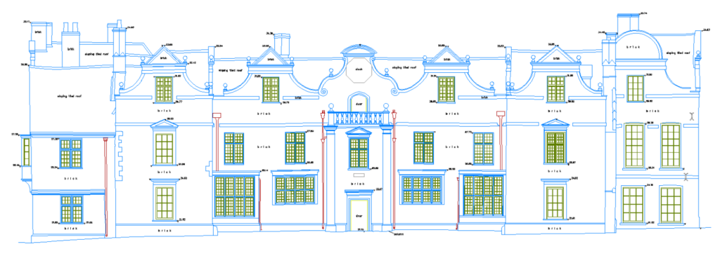
Precision for the City of Dreaming Spires
Oxford is a city of profound contrasts, where medieval colleges stand alongside world-class science parks. This unique blend of ancient heritage and cutting-edge innovation demands an unparalleled level of precision in its built environment. Every successful project, from the sensitive restoration of a listed building to the development of a new research facility, begins with a flawless understanding of the existing space.
Terrain Surveys provides measured building surveys that respect Oxford’s past while enabling its future. Whether you’re planning a sympathetic extension for a Victorian home in Summertown, documenting a complex university building, or reconfiguring commercial space in the city centre, we deliver the foundational accuracy your project requires.
What is a Measured Building Survey?
A measured building survey is the definitive process of capturing a structure’s exact dimensions and architectural features. Using advanced 3D laser scanners and traditional survey instruments, we create a precise digital record of the building as it stands today. This is not a structural or condition report; it is a survey focused purely on delivering accurate spatial data. The resulting 2D drawings or 3D models form the essential, reliable starting point for all architectural design, planning applications, and construction activities.
Your Oxford Project Deliverables
We provide clear, actionable data tailored to your project’s specific needs:
- 2D CAD Drawings: The standard for planning submissions. We produce meticulously detailed floor plans, elevations, and sections in DWG and PDF formats.
- 3D Revit Models: For projects utilising Building Information Modelling (BIM), we create intelligent 3D models that facilitate collaborative design, clash detection, and asset management.
- Point Cloud Data: The rich, raw 3D data from our laser scanners, delivered in formats like E57 or RCP for use by specialist consultants.
- Topographical Integration: We can seamlessly link your building survey to the wider site context, including land levels and Ordnance Survey coordinates.
All our surveys are conducted to high levels of accuracy as standard, following the professional guidelines set out by RICS and The Survey Association (TSA).
Supporting Homeowners Across Oxford
For homeowners in Oxford, from the terraced houses of Jericho to the family homes of Headington, a measured survey is the first step in realising your property’s potential. We provide the critical drawings that architects and builders rely on for:
- Home extensions that respect the character of areas like Cowley and Marston.
- Loft conversions to add valuable space.
- Internal refurbishments and reconfigurations.
- Accurate documentation for listed building consent applications.
Navigating the stringent planning process of Oxford City Council, especially within its many conservation areas, requires impeccable documentation. Our surveys provide the clarity and precision needed for a smooth and successful application.

The Legal & Standards Framework
In a city as historically significant as Oxford, the legal and regulatory context is paramount. A measured building survey is a critical document for:
- Planning Applications: Providing Oxford City Council with the required “existing” drawings.
- Listed Building Consent: Offering a precise record of heritage features before any work commences.
- Building Regulations: Ensuring compliance for all structural changes.
- Lease Plans: Creating Land Registry-compliant documents for commercial and residential properties.
We conduct all surveys in accordance with the latest RICS professional standard, “Measured Surveys of Land, Buildings and Utilities,” ensuring our work is defensible and fit for purpose.
BIM & Revit: Digital Solutions for Complex Environments
In a city at the forefront of research and technology, modern digital workflows are essential. Our BIM capabilities are designed to support the most demanding projects. We can provide:
- From basic massing models for feasibility studies to detailed models ready for construction documentation.
- Heritage BIM (HBIM): Creating detailed models of historic buildings that capture architectural nuances, structural elements, and degradation, providing an invaluable tool for conservation and management.
- Clash Detection: Helping to de-risk projects by identifying potential conflicts between structural and service elements before construction begins.
Industries & Sectors We Serve
- Homeowners and residential developers
- Architects and heritage consultants
- University and college estate managers
- Commercial property agents and developers
- Construction contractors
- Public sector bodies
- Managers of science parks and R&D facilities
Transparent Pricing for Oxford Projects
We provide clear, fixed-price quotations tailored to your requirements. The cost is influenced by:
- The overall size and architectural complexity of the building.
- The level of detail required and the final deliverables (e.g., 2D CAD vs. 3D BIM).
- The conditions of site access.
- The required delivery schedule.
Why Terrain Surveys is the Right Choice for Oxford
- Experience & Integrity: Established in 2004, we have built our reputation on reliability and professional integrity.
- Certified Quality: Our ISO 9001:2015 certification guarantees a robust and repeatable quality management process for every project.
- Technical Excellence: We invest in the latest laser scanning technology and provide continuous training to our surveyors, ensuring we deliver the highest quality data.
- Responsive Service: We understand that projects move quickly. We offer a standard 3-10 day turnaround and can accommodate urgent requests when required.
Your Oxford Project Starts with Certainty
Managing a project in Oxford means navigating a unique set of challenges. The need for accuracy & precision is absolute, and the margin for error is zero. Don’t risk your project’s success on inaccurate or incomplete information.
Begin with a foundation of certainty. Get in touch using the form below.