Expert Measured Surveys in the Capital
When it comes to property and development in London, precision is everything. A measured building survey is a detailed dimensional record of a building’s structure, capturing walls, floors, windows, rooflines and every architectural feature with high levels of accuracy. In a city where space is at a premium and planning regulations are stringent, architects, planners, and developers across London rely on these surveys to provide the foundation for design, refurbishment, or heritage conservation projects.
What You’ll Receive
Every London measured survey is tailored to the project’s needs, whether you’re modernising a townhouse in Chelsea, refurbishing office space in Canary Wharf, or seeking planning approval in Westminster. Typical deliverables include:
- 2D CAD drawings for floor plans, elevations and cross-sections
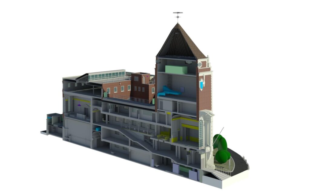
- 3D BIM/Revit models suitable for collaborative design workflows
- Point cloud datasets (E57, RCP, LAS) for in-depth visualisation
- Flexible outputs such as DWG and PDF files , all scaled and checked for accuracy
This means stakeholders, from structural engineers to local planning officers, can work from a common set of reliable, clear drawings.
Accuracy & Technology in London Projects
London’s mix of historic buildings and cutting-edge developments demands absolute accuracy & precision. Our surveys typically achieve ±5 mm accuracy , aligning with RICS and TSA guidelines. This is achieved using a combination of 3D laser scanning and high-precision total stations , capturing the intricate detailing found on Victorian terraces in Islington or Gothic spires in Southwark. The result: data you can trust, no matter how complex the structure.
Why Commission a Measured Survey in London?
In a fast-moving property market like London’s, measured surveys support a wide range of needs:
- Planning applications
- Conservation and restoration
- Commercial development
- Legal and disputes
- Space planning
Credentials You Can Rely On
Founded in 2004, Terrain Surveys has grown into a trusted nationwide surveying company. From our Hertfordshire head office and regional hubs, we provide a fast response across the capital. We are:
- ISO 9001:2015 accredited for quality management
- Members of the Chartered Institution of Civil Engineering Surveyors (CICES)
- Experienced with London’s unique challenges, from heritage restrictions around the Tower of London to the demands of major transport infrastructure projects
Company Background
Terrain Surveys began with a clear mission: to raise standards in UK surveying. Since 2004, we have supported projects ranging from hospital refurbishments in central London to theatres in the West End and residential developments on the outskirts of Greater London. Our directors remain actively involved in ensuring surveys are delivered quickly, accurately, and with integrity.

Technical Features
London’s environment often brings challenges such as restricted access, tight timeframes, and complex multi-storey layouts. To meet these, Terrain Surveys uses:
- 3D laser scanners to capture millions of data points per second, ideal for intricate Georgian façades or industrial conversions in Shoreditch
- Total stations & digital levels for precise height & level data, vital when integrating with London’s dense transport networks
- Quality assurance checks that guarantee drawings meet RICS standards before release
Client Sectors Across the Capital
We regularly support a wide range of London clients, including:
- Architects working on extensions
- Local authorities preserving heritage buildings
- Developers undertaking large-scale mixed-use schemes
- Conservation bodies recording historic churches and civic buildings
Legal & Standards Context in London
In a city governed by multiple planning authorities, measured building surveys play a crucial legal role. Borough councils expect surveys that adhere to the RICS Measured Surveys of Land, Buildings and Utilities Standard (3rd edition) . Accuracy tolerances, control points, and datums are agreed in advance, ensuring the drawings hold up in planning, lease negotiations, or legal disputes. For London projects, where rights of light and conservation area restrictions can halt progress, this level of compliance is essential.
Industry Context: London & Beyond
The demand for BIM-ready surveys has grown rapidly in London, especially on large transport hubs, hospitals, and university campuses. By delivering Revit models with the correct level of detail, Terrain Surveys ensures design teams can collaborate effectively on digital platforms. The city’s focus on digital twins and smart buildings means measured surveys are no longer just for drawings; they are becoming the backbone of long-term asset management.
Why Choose Us?
- Fast turnaround, even on urgent projects across the capital
- Flexible outputs tailored to architects, engineers, and planners
- Experience with everything from listed buildings to modern skyscrapers
- Trusted by major developers, councils, and heritage organisations
Whether you’re working on a conversion in Hackney , a new build in Croydon , or a restoration project in Mayfair , Terrain Surveys provides the precision data that makes projects possible.
Use the form at the bottom of this page to get in touch to discuss your survey requirements